McCleary elevation
McCleary (Washington, Grays Harbor County), United States elevation is 80 meters and McCleary elevation in feet is 262 ft above sea level [src 1]. McCleary is a populated place (feature code) with elevation that is 199 meters (653 ft) smaller than average city elevation in United States.
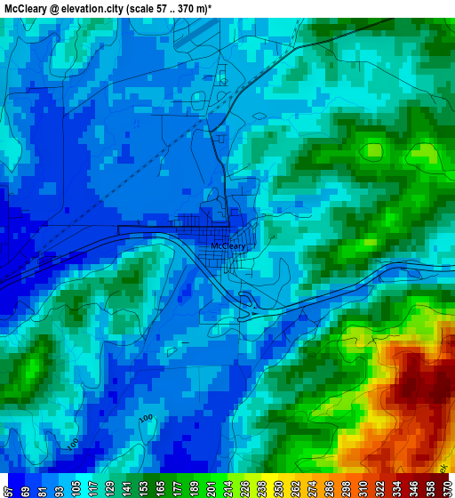
Below is the Elevation map of McCleary, which displays elevation range with different colors. Scale of the first map is from 57 to 370 m (187 to 1214 ft) with average elevation of 126.6 meters (=415 ft) [note 1]
These maps also provides idea of topography and contour of this city, they are displayed at different zoom levels. More info about maps, scale and edge coordinates you can find below images.
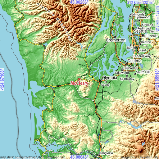
| \ | Map #1 | Topo.Map |
| Scale [m] | 57..370 m | × |
| Scale [ft] | 187..1214 ft | × |
| Average | 126.6 m = 415 ft | × |
| Width | 6.66 km = 4.1 mi | 213.1 km = 132.4 mi |
| Height | 6.66 km = 4.1 mi | 213.1 km = 132.4 mi |
| ↑Max Latitude | 47.083082° | 48.00266° |
| Latitude at center | 47.05315° | 47.05315° |
| ↓Min Latitude | 47.023201° | 46.08643° |
| ← Min Longitude | -123.309375° | -124.67168° |
| Longitude center | -123.26543° | -123.26543° |
| →Max Longitude | -123.221485° | -121.85918° |
Nearby cities:
Cities around McCleary sort by population:
• Olympia elevation 32 m
27.7 km,  93°
93°
• Lacey 62 m
33.6 km, 93°
• Tumwater 53 m
27.5 km,  100°
100°
• Shelton 6 m
21.9 km,  34°
34°
• Tanglewilde-Thompson Place 63 m
36.7 km, 90°
• Tanglewilde 62 m
36.6 km, 90°
• Montesano 16 m
26.8 km,  252°
252°
• Elma 17 m
12.2 km,  243°
243°
• Grand Mound 47 m
35.3 km,  146°
146°
• Central Park 43 m
33.6 km, 254°
• Rochester 42 m
28.8 km, 153°
• Tenino 86 m
38.2 km,  124°
124°
Multilingual:
 En español:
McCleary elevación 80 m.
 En France:
McCleary élévation 80 m.


Sources and notes:
- [note 1] Map square and city borders are not equal. Map elevation data is calculated only from area inside that square.
- [src 1] Elevation data from geonames database provided with same terms of usage.
- [src 2] The elevation map of McCleary is generated using elevation data from NASA's 3 arcsec (90m) resolution SRTM data.
- [src 3] Base (background) map © OpenStreetMap contributors tiles are generated by Geofabrik and OpenTopoMap.
Copyright & License:
This McCleary Elevation Map is licensed under CC BY-SA. You may reuse any part from this page, if you give a proper credit by linking to this URL:
 More info on terms of use page.