Kent elevation
Kent (Washington, King County), United States elevation is 14 meters and Kent elevation in feet is 46 ft above sea level [src 1]. Kent is a populated place (feature code) with elevation that is 265 meters (869 ft) smaller than average city elevation in United States.
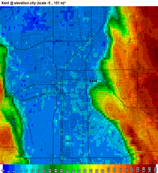
Below is the Elevation map of Kent, which displays elevation range with different colors. Scale of the first map is from -5 to 151 m (-16 to 495 ft) with average elevation of 46.1 meters (=151 ft) [note 1]
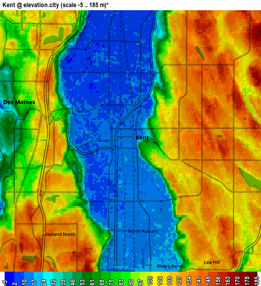
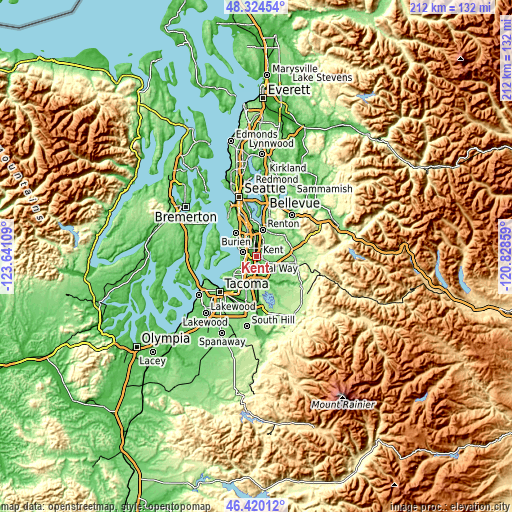
These maps also provides idea of topography and contour of this city, they are displayed at different zoom levels. More info about maps, scale and edge coordinates you can find below images.
| \ | Map #1 | Map #2 | Topo.Map |
| Scale [m] | -5..151 m | -5..185 m | × |
| Scale [ft] | -16..495 ft | -16..607 ft | × |
| Average | 46.1 m = 151 ft | 82.7 m = 271 ft | × |
| Width | 6.62 km = 4.1 mi | 13.23 km = 8.2 mi | 211.8 km = 131.6 mi |
| Height | 6.62 km = 4.1 mi | 13.23 km = 8.2 mi | 211.7 km = 131.5 mi |
| ↑Max Latitude | 47.410678° | 47.440409° | 48.32454° |
| Latitude at center | 47.38093° | 47.38093° | 47.38093° |
| ↓Min Latitude | 47.351165° | 47.321384° | 46.42012° |
| ← Min Longitude | -122.278785° | -122.322731° | -123.64109° |
| Longitude center | -122.23484° | -122.23484° | -122.23484° |
| →Max Longitude | -122.190895° | -122.146949° | -120.82859° |
Nearby cities:
Cities around Kent sort by population:
• Federal Way elevation 142 m
8.8 km,  221°
221°
• Auburn 25 m
8.2 km,  176°
176°
• Des Moines 27 m
7.1 km,  288°
288°
• East Hill-Meridian 156 m
5.7 km,  54°
54°
• SeaTac 126 m
8.7 km,  330°
330°
• Tukwila 43 m
10.5 km,  349°
349°
• Covington 111 m
8.9 km,  106°
106°
• Fairwood 161 m
9.5 km,  37°
37°
• Lea Hill 128 m
7.3 km,  146°
146°
• Lakeland North 139 m
6.2 km,  210°
210°
• Lake Morton-Berrydale 141 m
11.3 km,  118°
118°
• Normandy Park 90 m
10.1 km,  307°
307°
Multilingual:
 En español:
Kent elevación 14 m.
 En France:
Kent élévation 14 m.


Sources and notes:
- [note 1] Map square and city borders are not equal. Map elevation data is calculated only from area inside that square.
- [src 1] Elevation data from geonames database provided with same terms of usage.
- [src 2] The elevation map of Kent is generated using elevation data from NASA's 3 arcsec (90m) resolution SRTM data.
- [src 3] Base (background) map © OpenStreetMap contributors tiles are generated by Geofabrik and OpenTopoMap.
Copyright & License:
This Kent Elevation Map is licensed under CC BY-SA. You may reuse any part from this page, if you give a proper credit by linking to this URL:
 More info on terms of use page.