Auburn elevation
Auburn (Washington, King County), United States elevation is 25 meters and Auburn elevation in feet is 82 ft above sea level [src 1]. Auburn is a populated place (feature code) with elevation that is 254 meters (833 ft) smaller than average city elevation in United States.
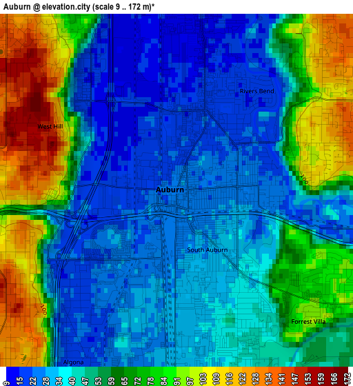
Below is the Elevation map of Auburn, which displays elevation range with different colors. Scale of the first map is from 9 to 172 m (30 to 564 ft) with average elevation of 53.5 meters (=176 ft) [note 1]
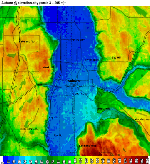
These maps also provides idea of topography and contour of this city, they are displayed at different zoom levels. More info about maps, scale and edge coordinates you can find below images.
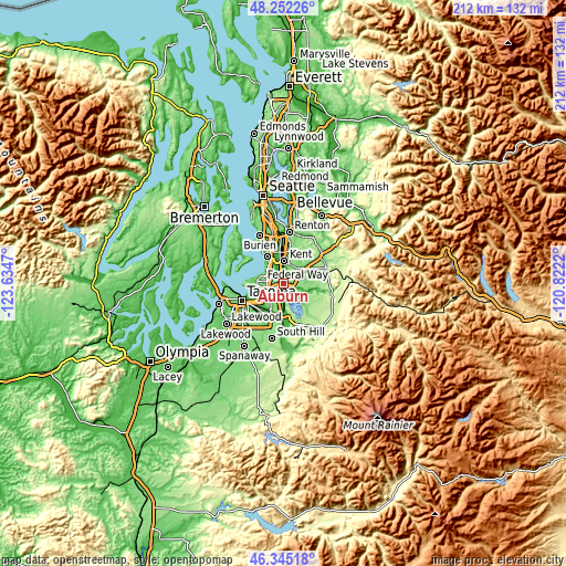
| \ | Map #1 | Map #2 | Topo.Map |
| Scale [m] | 9..172 m | 3..205 m | × |
| Scale [ft] | 30..564 ft | 10..673 ft | × |
| Average | 53.5 m = 176 ft | 86.1 m = 282 ft | × |
| Width | 6.63 km = 4.1 mi | 13.25 km = 8.2 mi | 212 km = 131.7 mi |
| Height | 6.63 km = 4.1 mi | 13.25 km = 8.2 mi | 212 km = 131.7 mi |
| ↑Max Latitude | 47.337109° | 47.366882° | 48.25226° |
| Latitude at center | 47.30732° | 47.30732° | 47.30732° |
| ↓Min Latitude | 47.277514° | 47.247691° | 46.34518° |
| ← Min Longitude | -122.272395° | -122.316341° | -123.6347° |
| Longitude center | -122.22845° | -122.22845° | -122.22845° |
| →Max Longitude | -122.184505° | -122.140559° | -120.8222° |
Nearby cities:
Cities around Auburn sort by population:
• Kent elevation 14 m
8.2 km,  356°
356°
• Federal Way 142 m
6.6 km,  284°
284°
• Covington 111 m
9.8 km,  54°
54°
• Lea Hill 128 m
4.1 km,  59°
59°
• Lakeland North 139 m
4.7 km,  308°
308°
• Lakeland South 130 m
5.2 km,  232°
232°
• Lake Morton-Berrydale 141 m
9.9 km,  73°
73°
• Edgewood 107 m
8 km,  217°
217°
• Milton 93 m
9.2 km, 224°
• Pacific 23 m
5 km,  198°
198°
• Algona 19 m
3.6 km,  209°
209°
• Fife Heights 126 m
10.3 km,  238°
238°
Multilingual:
 En español:
Auburn elevación 25 m.
 En France:
Auburn élévation 25 m.


Sources and notes:
- [note 1] Map square and city borders are not equal. Map elevation data is calculated only from area inside that square.
- [src 1] Elevation data from geonames database provided with same terms of usage.
- [src 2] The elevation map of Auburn is generated using elevation data from NASA's 3 arcsec (90m) resolution SRTM data.
- [src 3] Base (background) map © OpenStreetMap contributors tiles are generated by Geofabrik and OpenTopoMap.
Copyright & License:
This Auburn Elevation Map is licensed under CC BY-SA. You may reuse any part from this page, if you give a proper credit by linking to this URL:
 More info on terms of use page.