Granger elevation
Granger (Washington, Yakima County), United States elevation is 222 meters and Granger elevation in feet is 728 ft above sea level [src 1]. Granger is a populated place (feature code) with elevation that is 57 meters (187 ft) smaller than average city elevation in United States.
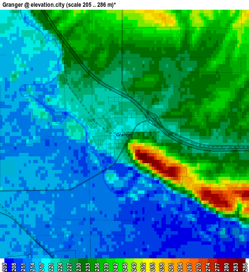
Below is the Elevation map of Granger, which displays elevation range with different colors. Scale of the first map is from 205 to 286 m (673 to 938 ft) with average elevation of 225.1 meters (=739 ft) [note 1]
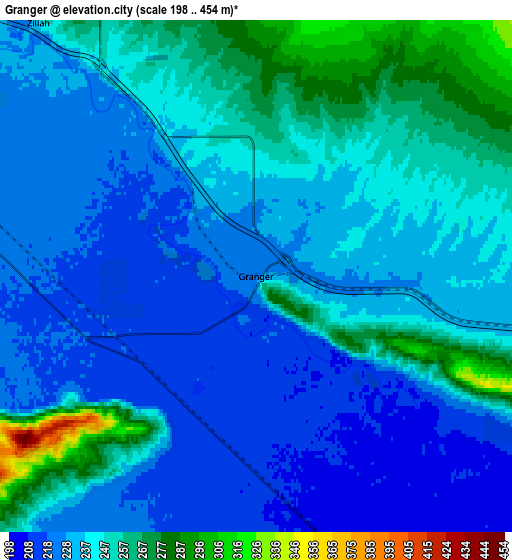
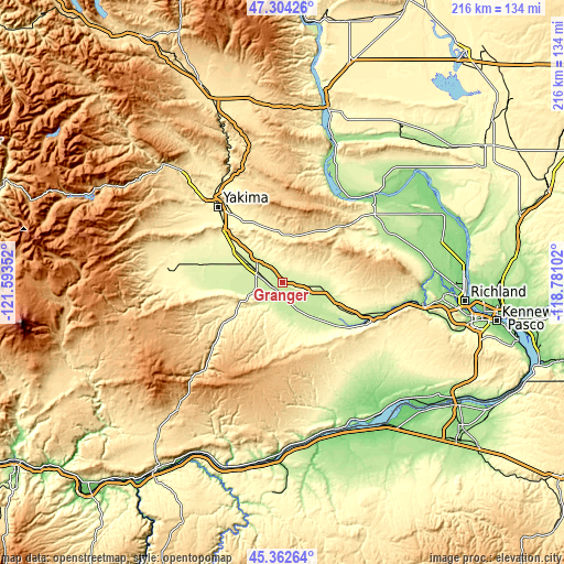
These maps also provides idea of topography and contour of this city, they are displayed at different zoom levels. More info about maps, scale and edge coordinates you can find below images.
| \ | Map #1 | Map #2 | Topo.Map |
| Scale [m] | 205..286 m | 198..454 m | × |
| Scale [ft] | 673..938 ft | 650..1490 ft | × |
| Average | 225.1 m = 739 ft | 237.6 m = 780 ft | × |
| Width | 6.75 km = 4.2 mi | 13.49 km = 8.4 mi | 215.9 km = 134.2 mi |
| Height | 6.75 km = 4.2 mi | 13.49 km = 8.4 mi | 215.9 km = 134.2 mi |
| ↑Max Latitude | 46.372399° | 46.402712° | 47.30426° |
| Latitude at center | 46.34207° | 46.34207° | 46.34207° |
| ↓Min Latitude | 46.311724° | 46.281361° | 45.36264° |
| ← Min Longitude | -120.231215° | -120.275161° | -121.59352° |
| Longitude center | -120.18727° | -120.18727° | -120.18727° |
| →Max Longitude | -120.143325° | -120.099379° | -118.78102° |
Nearby cities:
Cities around Granger sort by population:
• Yakima elevation 325 m
37.8 km,  319°
319°
• Sunnyside 227 m
13.9 km,  98°
98°
• West Valley 360 m
42.4 km,  310°
310°
• Grandview 245 m
24.2 km,  114°
114°
• Toppenish 232 m
10.1 km,  292°
292°
• Terrace Heights 357 m
35.2 km,  326°
326°
• Union Gap 297 m
32.5 km, 317°
• Prosser 203 m
35.5 km,  115°
115°
• Wapato 261 m
21.4 km,  303°
303°
• Ahtanum 378 m
41.2 km, 305°
• Zillah 246 m
8.8 km, 319°
• Mabton 218 m
20.4 km,  134°
134°
Multilingual:
 En español:
Granger elevación 222 m.
 En France:
Granger élévation 222 m.


Sources and notes:
- [note 1] Map square and city borders are not equal. Map elevation data is calculated only from area inside that square.
- [src 1] Elevation data from geonames database provided with same terms of usage.
- [src 2] The elevation map of Granger is generated using elevation data from NASA's 3 arcsec (90m) resolution SRTM data.
- [src 3] Base (background) map © OpenStreetMap contributors tiles are generated by Geofabrik and OpenTopoMap.
Copyright & License:
This Granger Elevation Map is licensed under CC BY-SA. You may reuse any part from this page, if you give a proper credit by linking to this URL:
 More info on terms of use page.