Felida elevation
Felida (Washington, Clark County), United States elevation is 63 meters and Felida elevation in feet is 207 ft above sea level [src 1]. Felida is a populated place (feature code) with elevation that is 216 meters (709 ft) smaller than average city elevation in United States.
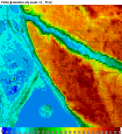
Below is the Elevation map of Felida, which displays elevation range with different colors. Scale of the first map is from -12 to 78 m (-39 to 256 ft) with average elevation of 32.9 meters (=108 ft) [note 1]
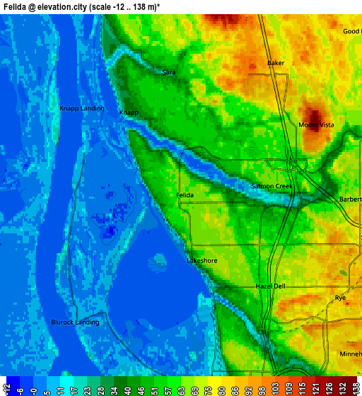
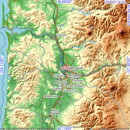
These maps also provides idea of topography and contour of this city, they are displayed at different zoom levels. More info about maps, scale and edge coordinates you can find below images.
| \ | Map #1 | Map #2 | Topo.Map |
| Scale [m] | -12..78 m | -12..138 m | × |
| Scale [ft] | -39..256 ft | -39..453 ft | × |
| Average | 32.9 m = 108 ft | 37.7 m = 124 ft | × |
| Width | 6.82 km = 4.2 mi | 13.65 km = 8.5 mi | 218.4 km = 135.7 mi |
| Height | 6.82 km = 4.2 mi | 13.65 km = 8.5 mi | 218.4 km = 135.7 mi |
| ↑Max Latitude | 45.740238° | 45.7709° | 46.68292° |
| Latitude at center | 45.70956° | 45.70956° | 45.70956° |
| ↓Min Latitude | 45.678865° | 45.648153° | 44.71895° |
| ← Min Longitude | -122.751265° | -122.795211° | -124.11357° |
| Longitude center | -122.70732° | -122.70732° | -122.70732° |
| →Max Longitude | -122.663375° | -122.619429° | -121.30107° |
Nearby cities:
Cities around Felida sort by population:
• Vancouver elevation 57 m
8.6 km,  155°
155°
• Salmon Creek 52 m
4.5 km,  88°
88°
• Hazel Dell 66 m
5.5 km,  140°
140°
• Five Corners 65 m
10.6 km,  105°
105°
• Walnut Grove 85 m
9.6 km,  118°
118°
• Minnehaha 80 m
7.2 km, 140°
• Mount Vista 72 m
6.4 km,  64°
64°
• North Portland 13 m
11 km,  178°
178°
• Lake Shore 66 m
2.5 km,  148°
148°
• Ridgefield 36 m
12.1 km,  346°
346°
• Barberton 75 m
8.6 km,  102°
102°
• Dollar Corner 67 m
11.4 km,  46°
46°
Multilingual:
 En español:
Felida elevación 63 m.
 En France:
Felida élévation 63 m.


Sources and notes:
- [note 1] Map square and city borders are not equal. Map elevation data is calculated only from area inside that square.
- [src 1] Elevation data from geonames database provided with same terms of usage.
- [src 2] The elevation map of Felida is generated using elevation data from NASA's 3 arcsec (90m) resolution SRTM data.
- [src 3] Base (background) map © OpenStreetMap contributors tiles are generated by Geofabrik and OpenTopoMap.
Copyright & License:
This Felida Elevation Map is licensed under CC BY-SA. You may reuse any part from this page, if you give a proper credit by linking to this URL:
 More info on terms of use page.