Barberton elevation
Barberton (Washington, Clark County), United States elevation is 75 meters and Barberton elevation in feet is 246 ft above sea level [src 1]. Barberton is a populated place (feature code) with elevation that is 204 meters (669 ft) smaller than average city elevation in United States.
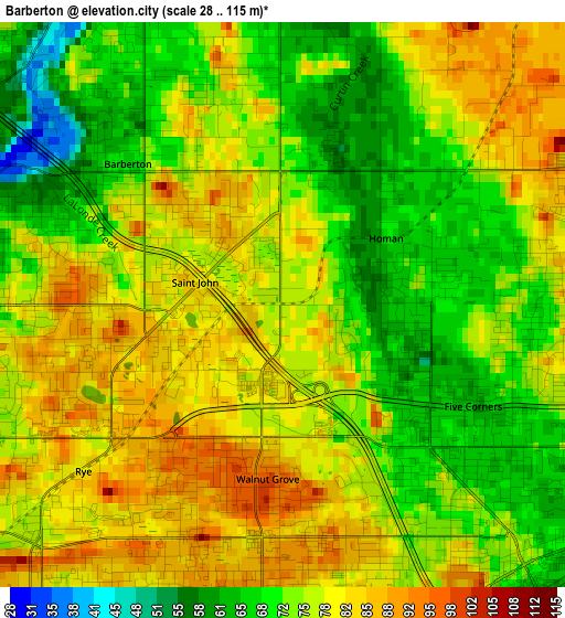
Below is the Elevation map of Barberton, which displays elevation range with different colors. Scale of the first map is from 28 to 115 m (92 to 377 ft) with average elevation of 75.6 meters (=248 ft) [note 1]
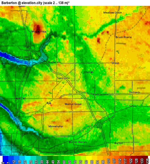
These maps also provides idea of topography and contour of this city, they are displayed at different zoom levels. More info about maps, scale and edge coordinates you can find below images.
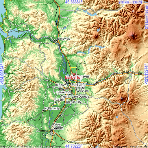
| \ | Map #1 | Map #2 | Topo.Map |
| Scale [m] | 28..115 m | 2..138 m | × |
| Scale [ft] | 92..377 ft | 7..453 ft | × |
| Average | 75.6 m = 248 ft | 72.7 m = 239 ft | × |
| Width | 6.83 km = 4.2 mi | 13.65 km = 8.5 mi | 218.4 km = 135.7 mi |
| Height | 6.83 km = 4.2 mi | 13.65 km = 8.5 mi | 218.4 km = 135.7 mi |
| ↑Max Latitude | 45.723857° | 45.754528° | 46.66681° |
| Latitude at center | 45.69317° | 45.69317° | 45.69317° |
| ↓Min Latitude | 45.662466° | 45.631745° | 44.70228° |
| ← Min Longitude | -122.642935° | -122.686881° | -124.00524° |
| Longitude center | -122.59899° | -122.59899° | -122.59899° |
| →Max Longitude | -122.555045° | -122.511099° | -121.19274° |
Nearby cities:
Cities around Barberton sort by population:
• Vancouver elevation 57 m
7.8 km,  218°
218°
• Salmon Creek 52 m
4.3 km,  296°
296°
• Orchards 71 m
4.2 km,  135°
135°
• Hazel Dell 66 m
5.5 km,  244°
244°
• Five Corners 65 m
2.1 km,  117°
117°
• Walnut Grove 85 m
2.8 km,  180°
180°
• Minnehaha 80 m
5.4 km,  225°
225°
• Mount Vista 72 m
5.3 km,  330°
330°
• Felida 63 m
8.6 km,  282°
282°
• Lake Shore 66 m
7.1 km,  267°
267°
• Brush Prairie 92 m
6 km,  42°
42°
• Meadow Glade 86 m
7.9 km,  22°
22°
Multilingual:
 En español:
Barberton elevación 75 m.
 En France:
Barberton élévation 75 m.
 Auf Deutsch:
Barberton höhe über dem Meeresspiegel ist 75 m.

Sources and notes:
- [note 1] Map square and city borders are not equal. Map elevation data is calculated only from area inside that square.
- [src 1] Elevation data from geonames database provided with same terms of usage.
- [src 2] The elevation map of Barberton is generated using elevation data from NASA's 3 arcsec (90m) resolution SRTM data.
- [src 3] Base (background) map © OpenStreetMap contributors tiles are generated by Geofabrik and OpenTopoMap.
Copyright & License:
This Barberton Elevation Map is licensed under CC BY-SA. You may reuse any part from this page, if you give a proper credit by linking to this URL:
 More info on terms of use page.