Cathlamet elevation
Cathlamet (Washington, Wahkiakum County), United States elevation is 26 meters and Cathlamet elevation in feet is 85 ft above sea level [src 1]. Cathlamet is a seat of a second-order administrative division (feature code) with elevation that is 253 meters (830 ft) smaller than average city elevation in United States.
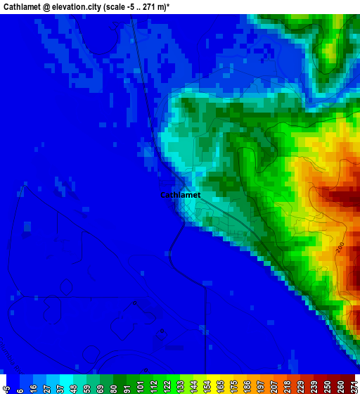
Below is the Elevation map of Cathlamet, which displays elevation range with different colors. Scale of the first map is from -5 to 271 m (-16 to 889 ft) with average elevation of 34.7 meters (=114 ft) [note 1]
These maps also provides idea of topography and contour of this city, they are displayed at different zoom levels. More info about maps, scale and edge coordinates you can find below images.
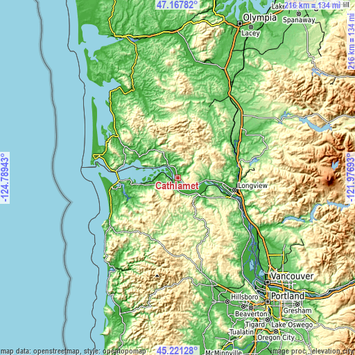
| \ | Map #1 | Topo.Map |
| Scale [m] | -5..271 m | × |
| Scale [ft] | -16..889 ft | × |
| Average | 34.7 m = 114 ft | × |
| Width | 6.76 km = 4.2 mi | 216.4 km = 134.5 mi |
| Height | 6.76 km = 4.2 mi | 216.4 km = 134.5 mi |
| ↑Max Latitude | 46.233576° | 47.16782° |
| Latitude at center | 46.20317° | 46.20317° |
| ↓Min Latitude | 46.172747° | 45.22128° |
| ← Min Longitude | -123.427125° | -124.78943° |
| Longitude center | -123.38318° | -123.38318° |
| →Max Longitude | -123.339235° | -121.97693° |
Nearby cities:
Cities around Cathlamet sort by population:
• Longview elevation 10 m
35 km,  101°
101°
• Kelso 21 m
37.1 km, 99°
• Astoria 10 m
34.5 km,  267°
267°
• West Side Highway 15 m
35.9 km,  93°
93°
• Warrenton 2 m
41.8 km,  264°
264°
• Longview Heights 276 m
32.9 km, 94°
• West Longview 2 m
29.8 km, 97°
• Castle Rock 17 m
37.4 km,  77°
77°
• Vernonia 188 m
41 km,  159°
159°
• Rainier 15 m
36.7 km,  110°
110°
• Clatskanie 32 m
17.7 km,  129°
129°
• Gearhart 6 m
45.3 km,  243°
243°
Multilingual:
 En español:
Cathlamet elevación 26 m.
 En France:
Cathlamet élévation 26 m.
 Auf Deutsch:
Cathlamet höhe über dem Meeresspiegel ist 26 m.

Sources and notes:
- [note 1] Map square and city borders are not equal. Map elevation data is calculated only from area inside that square.
- [src 1] Elevation data from geonames database provided with same terms of usage.
- [src 2] The elevation map of Cathlamet is generated using elevation data from NASA's 3 arcsec (90m) resolution SRTM data.
- [src 3] Base (background) map © OpenStreetMap contributors tiles are generated by Geofabrik and OpenTopoMap.
Copyright & License:
This Cathlamet Elevation Map is licensed under CC BY-SA. You may reuse any part from this page, if you give a proper credit by linking to this URL:
 More info on terms of use page.