Riverton elevation
Riverton (Utah, Salt Lake County), United States elevation is 1357 meters and Riverton elevation in feet is 4452 ft above sea level [src 1]. Riverton is a populated place (feature code) with elevation that is 1078 meters (3537 ft) bigger than average city elevation in United States.
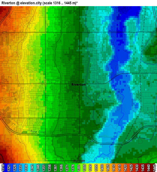
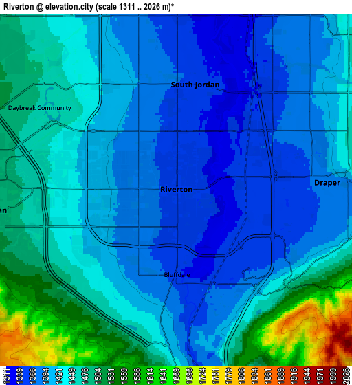
Below is the Elevation map of Riverton, which displays elevation range with different colors. Scale of the first map is from 1316 to 1445 m (4318 to 4741 ft) with average elevation of 1364.7 meters (=4477 ft) [note 1]
These maps also provides idea of topography and contour of this city, they are displayed at different zoom levels. More info about maps, scale and edge coordinates you can find below images.
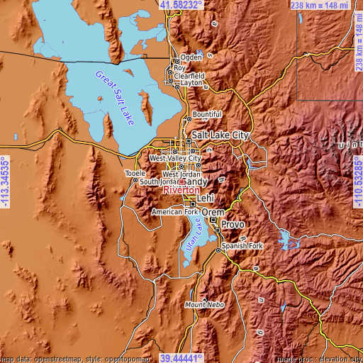
| \ | Map #1 | Map #2 | Topo.Map |
| Scale [m] | 1316..1445 m | 1311..2026 m | × |
| Scale [ft] | 4318..4741 ft | 4301..6647 ft | × |
| Average | 1364.7 m = 4477 ft | 1435.5 m = 4710 ft | × |
| Width | 7.43 km = 4.6 mi | 14.86 km = 9.2 mi | 237.7 km = 147.7 mi |
| Height | 7.43 km = 4.6 mi | 14.86 km = 9.2 mi | 237.7 km = 147.7 mi |
| ↑Max Latitude | 40.555287° | 40.588667° | 41.58232° |
| Latitude at center | 40.52189° | 40.52189° | 40.52189° |
| ↓Min Latitude | 40.488476° | 40.455046° | 39.44441° |
| ← Min Longitude | -111.983045° | -112.026991° | -113.34535° |
| Longitude center | -111.9391° | -111.9391° | -111.9391° |
| →Max Longitude | -111.895155° | -111.851209° | -110.53285° |
Nearby cities:
Cities around Riverton sort by population:
• West Jordan elevation 1338 m
9.8 km,  0°
0°
• Sandy Hills 1459 m
9.9 km,  48°
48°
• Sandy 1366 m
9 km,  30°
30°
• South Jordan 1358 m
4.5 km,  10°
10°
• Draper 1377 m
6.4 km,  87°
87°
• South Jordan Heights 1381 m
4.7 km,  349°
349°
• Midvale 1341 m
10.5 km,  18°
18°
• Herriman 1511 m
8 km,  263°
263°
• Bluffdale 1357 m
3.6 km,  179°
179°
• Little Cottonwood Creek Valley 1415 m
13 km, 45°
• White City 1398 m
8 km, 52°
• Granite 1571 m
12.6 km,  63°
63°
Multilingual:
 En español:
Riverton elevación 1357 m.
 En France:
Riverton élévation 1357 m.
 Auf Deutsch:
Riverton höhe über dem Meeresspiegel ist 1357 m.

Sources and notes:
- [note 1] Map square and city borders are not equal. Map elevation data is calculated only from area inside that square.
- [src 1] Elevation data from geonames database provided with same terms of usage.
- [src 2] The elevation map of Riverton is generated using elevation data from NASA's 3 arcsec (90m) resolution SRTM data.
- [src 3] Base (background) map © OpenStreetMap contributors tiles are generated by Geofabrik and OpenTopoMap.
Copyright & License:
This Riverton Elevation Map is licensed under CC BY-SA. You may reuse any part from this page, if you give a proper credit by linking to this URL:
 More info on terms of use page.