Lehi elevation
Lehi (Utah, Utah County), United States elevation is 1397 meters and Lehi elevation in feet is 4583 ft above sea level [src 1]. Lehi is a populated place (feature code) with elevation that is 1118 meters (3668 ft) bigger than average city elevation in United States.
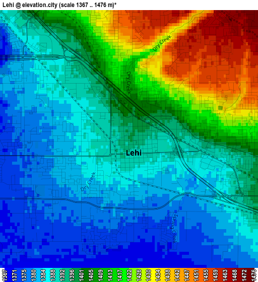
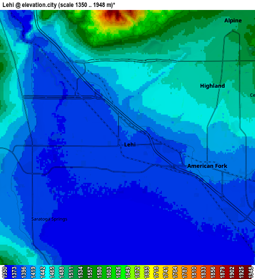
Below is the Elevation map of Lehi, which displays elevation range with different colors. Scale of the first map is from 1367 to 1476 m (4485 to 4843 ft) with average elevation of 1397.9 meters (=4586 ft) [note 1]
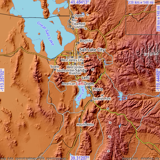
These maps also provides idea of topography and contour of this city, they are displayed at different zoom levels. More info about maps, scale and edge coordinates you can find below images.
| \ | Map #1 | Map #2 | Topo.Map |
| Scale [m] | 1367..1476 m | 1350..1948 m | × |
| Scale [ft] | 4485..4843 ft | 4429..6391 ft | × |
| Average | 1397.9 m = 4586 ft | 1425.2 m = 4676 ft | × |
| Width | 7.44 km = 4.6 mi | 14.89 km = 9.3 mi | 238.2 km = 148 mi |
| Height | 7.44 km = 4.6 mi | 14.89 km = 9.3 mi | 238.2 km = 148 mi |
| ↑Max Latitude | 40.425082° | 40.458527° | 41.45413° |
| Latitude at center | 40.39162° | 40.39162° | 40.39162° |
| ↓Min Latitude | 40.358141° | 40.324646° | 39.31207° |
| ← Min Longitude | -111.894715° | -111.938661° | -113.25702° |
| Longitude center | -111.85077° | -111.85077° | -111.85077° |
| →Max Longitude | -111.806825° | -111.762879° | -110.44452° |
Nearby cities:
Cities around Lehi sort by population:
• Draper elevation 1377 m
14.8 km,  355°
355°
• Riverton 1357 m
16.3 km,  332°
332°
• Pleasant Grove 1416 m
10 km,  107°
107°
• American Fork 1410 m
4.9 km, 109°
• Eagle Mountain 1489 m
15.8 km,  236°
236°
• Saratoga Springs 1378 m
6.6 km,  224°
224°
• Highland 1488 m
6.1 km,  51°
51°
• Bluffdale 1357 m
13.2 km, 325°
• Lindon 1418 m
12.3 km,  116°
116°
• Cedar Hills 1517 m
8.2 km,  72°
72°
• Alpine 1512 m
9.2 km,  41°
41°
• Vineyard 1380 m
13.7 km,  140°
140°
Multilingual:
 En español:
Lehi elevación 1397 m.
 En France:
Lehi élévation 1397 m.


Sources and notes:
- [note 1] Map square and city borders are not equal. Map elevation data is calculated only from area inside that square.
- [src 1] Elevation data from geonames database provided with same terms of usage.
- [src 2] The elevation map of Lehi is generated using elevation data from NASA's 3 arcsec (90m) resolution SRTM data.
- [src 3] Base (background) map © OpenStreetMap contributors tiles are generated by Geofabrik and OpenTopoMap.
Copyright & License:
This Lehi Elevation Map is licensed under CC BY-SA. You may reuse any part from this page, if you give a proper credit by linking to this URL:
 More info on terms of use page.