Layton elevation
Layton (Utah, Davis County), United States elevation is 1327 meters and Layton elevation in feet is 4354 ft above sea level [src 1]. Layton is a populated place (feature code) with elevation that is 1048 meters (3438 ft) bigger than average city elevation in United States.
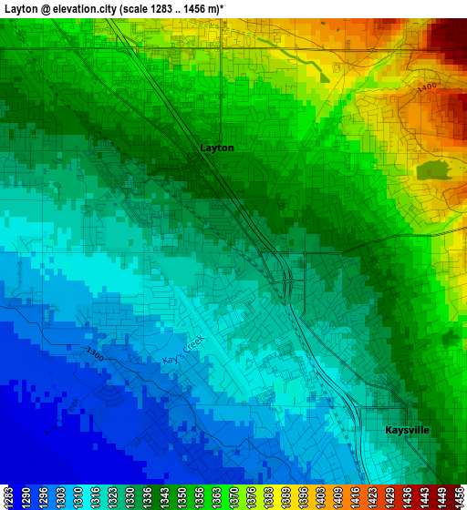
Below is the Elevation map of Layton, which displays elevation range with different colors. Scale of the first map is from 1283 to 1456 m (4209 to 4777 ft) with average elevation of 1337.5 meters (=4388 ft) [note 1]
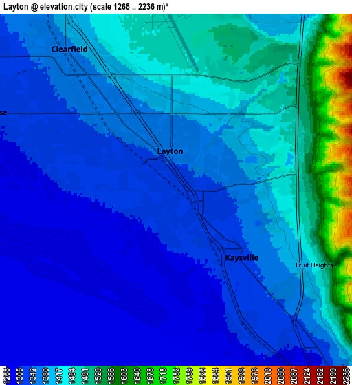
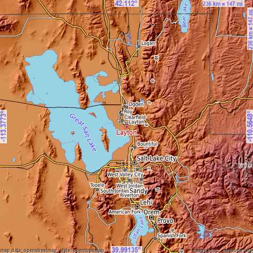
These maps also provides idea of topography and contour of this city, they are displayed at different zoom levels. More info about maps, scale and edge coordinates you can find below images.
| \ | Map #1 | Map #2 | Topo.Map |
| Scale [m] | 1283..1456 m | 1268..2236 m | × |
| Scale [ft] | 4209..4777 ft | 4160..7336 ft | × |
| Average | 1337.5 m = 4388 ft | 1390.4 m = 4562 ft | × |
| Width | 7.37 km = 4.6 mi | 14.74 km = 9.2 mi | 235.8 km = 146.5 mi |
| Height | 7.37 km = 4.6 mi | 14.74 km = 9.2 mi | 235.8 km = 146.5 mi |
| ↑Max Latitude | 41.093347° | 41.126458° | 42.112° |
| Latitude at center | 41.06022° | 41.06022° | 41.06022° |
| ↓Min Latitude | 41.027076° | 40.993915° | 39.99135° |
| ← Min Longitude | -112.014995° | -112.058941° | -113.3773° |
| Longitude center | -111.97105° | -111.97105° | -111.97105° |
| →Max Longitude | -111.927105° | -111.883159° | -110.5648° |
Nearby cities:
Cities around Layton sort by population:
• Roy elevation 1385 m
12.2 km,  337°
337°
• Clearfield 1365 m
7.3 km,  320°
320°
• Kaysville 1332 m
3.9 km,  135°
135°
• Syracuse 1308 m
8.5 km,  292°
292°
• Farmington 1315 m
11.3 km, 141°
• Clinton 1339 m
11.1 km, 322°
• West Point 1317 m
11.5 km,  304°
304°
• South Weber 1380 m
8.7 km,  23°
23°
• Fruit Heights 1431 m
6.6 km,  118°
118°
• Sunset 1378 m
9.8 km,  329°
329°
• Hill Air Force Base 1461 m
5.7 km,  354°
354°
• Uintah 1385 m
10.2 km, 23°
Multilingual:
 En español:
Layton elevación 1327 m.
 En France:
Layton élévation 1327 m.


Sources and notes:
- [note 1] Map square and city borders are not equal. Map elevation data is calculated only from area inside that square.
- [src 1] Elevation data from geonames database provided with same terms of usage.
- [src 2] The elevation map of Layton is generated using elevation data from NASA's 3 arcsec (90m) resolution SRTM data.
- [src 3] Base (background) map © OpenStreetMap contributors tiles are generated by Geofabrik and OpenTopoMap.
Copyright & License:
This Layton Elevation Map is licensed under CC BY-SA. You may reuse any part from this page, if you give a proper credit by linking to this URL:
 More info on terms of use page.