Canyon Rim elevation
Canyon Rim (Utah, Salt Lake County), United States elevation is 1413 meters and Canyon Rim elevation in feet is 4636 ft above sea level [src 1]. Canyon Rim is a populated place (feature code) with elevation that is 1134 meters (3720 ft) bigger than average city elevation in United States.
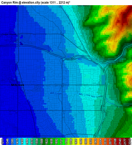
Below is the Elevation map of Canyon Rim, which displays elevation range with different colors. Scale of the first map is from 1311 to 2212 m (4301 to 7257 ft) with average elevation of 1473.6 meters (=4835 ft) [note 1]
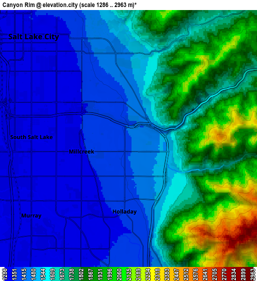
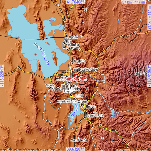
These maps also provides idea of topography and contour of this city, they are displayed at different zoom levels. More info about maps, scale and edge coordinates you can find below images.
| \ | Map #1 | Map #2 | Topo.Map |
| Scale [m] | 1311..2212 m | 1286..2963 m | × |
| Scale [ft] | 4301..7257 ft | 4219..9721 ft | × |
| Average | 1473.6 m = 4835 ft | 1596 m = 5236 ft | × |
| Width | 7.41 km = 4.6 mi | 14.82 km = 9.2 mi | 237.1 km = 147.3 mi |
| Height | 7.41 km = 4.6 mi | 14.82 km = 9.2 mi | 237.1 km = 147.3 mi |
| ↑Max Latitude | 40.739915° | 40.773203° | 41.76408° |
| Latitude at center | 40.70661° | 40.70661° | 40.70661° |
| ↓Min Latitude | 40.673289° | 40.63995° | 39.63207° |
| ← Min Longitude | -111.865825° | -111.909771° | -113.22813° |
| Longitude center | -111.82188° | -111.82188° | -111.82188° |
| →Max Longitude | -111.777935° | -111.733989° | -110.41563° |
Nearby cities:
Cities around Canyon Rim sort by population:
• Salt Lake City elevation 1311 m
8.4 km,  315°
315°
• Millcreek 1309 m
5 km,  244°
244°
• Taylorsville 1314 m
10.8 km,  246°
246°
• Murray 1317 m
7.1 km,  231°
231°
• Cottonwood Heights 1473 m
9.7 km,  174°
174°
• Holladay 1363 m
4.2 km,  183°
183°
• South Salt Lake 1299 m
5.8 km,  283°
283°
• East Millcreek 1457 m
1.2 km,  127°
127°
• Little Cottonwood Creek Valley 1415 m
11.4 km, 183°
• Mount Olympus 1565 m
3.7 km, 129°
• Willard 1378 m
1.3 km,  268°
268°
• Centerfield 1300 m
6.6 km,  255°
255°
Multilingual:
 En español:
Canyon Rim elevación 1413 m.
 En France:
Canyon Rim élévation 1413 m.
 Auf Deutsch:
Canyon Rim höhe über dem Meeresspiegel ist 1413 m.

Sources and notes:
- [note 1] Map square and city borders are not equal. Map elevation data is calculated only from area inside that square.
- [src 1] Elevation data from geonames database provided with same terms of usage.
- [src 2] The elevation map of Canyon Rim is generated using elevation data from NASA's 3 arcsec (90m) resolution SRTM data.
- [src 3] Base (background) map © OpenStreetMap contributors tiles are generated by Geofabrik and OpenTopoMap.
Copyright & License:
This Canyon Rim Elevation Map is licensed under CC BY-SA. You may reuse any part from this page, if you give a proper credit by linking to this URL:
 More info on terms of use page.