Philip elevation
Philip (South Dakota, Haakon County), United States elevation is 658 meters and Philip elevation in feet is 2159 ft above sea level [src 1]. Philip is a seat of a second-order administrative division (feature code) with elevation that is 379 meters (1243 ft) bigger than average city elevation in United States.
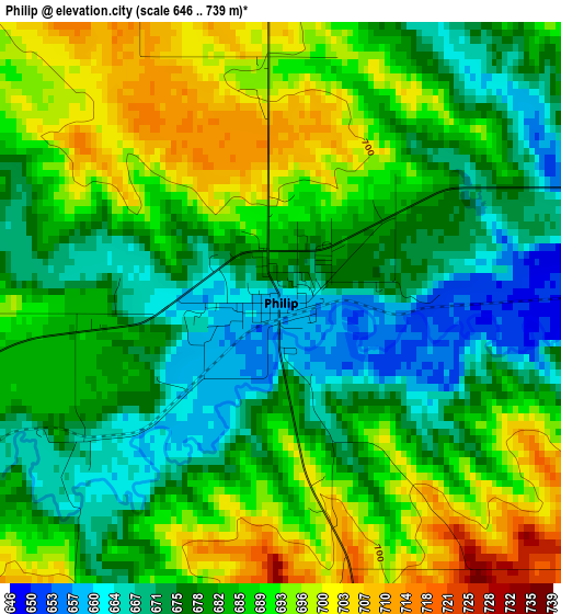
Below is the Elevation map of Philip, which displays elevation range with different colors. Scale of the first map is from 646 to 739 m (2119 to 2425 ft) with average elevation of 683.5 meters (=2242 ft) [note 1]
These maps also provides idea of topography and contour of this city, they are displayed at different zoom levels. More info about maps, scale and edge coordinates you can find below images.
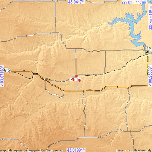
| \ | Map #1 | Topo.Map |
| Scale [m] | 646..739 m | × |
| Scale [ft] | 2119..2425 ft | × |
| Average | 683.5 m = 2242 ft | × |
| Width | 7.03 km = 4.4 mi | 224.8 km = 139.7 mi |
| Height | 7.03 km = 4.4 mi | 224.8 km = 139.7 mi |
| ↑Max Latitude | 44.071012° | 45.0417° |
| Latitude at center | 44.03943° | 44.03943° |
| ↓Min Latitude | 44.007831° | 43.01991° |
| ← Min Longitude | -101.709085° | -103.07139° |
| Longitude center | -101.66514° | -101.66514° |
| →Max Longitude | -101.621195° | -100.25889° |
Nearby cities:
Cities around Philip sort by population:
• Pierre elevation 450 m
110.9 km,  70°
70°
• Box Elder 924 m
112.4 km,  274°
274°
• Fort Pierre 436 m
108.7 km, 71°
• North Eagle Butte 735 m
112.6 km,  17°
17°
• Rosebud 804 m
111 km,  143°
143°
• Eagle Butte 736 m
112.4 km, 17°
• Porcupine 971 m
103.8 km,  211°
211°
• Martin 1008 m
96.5 km,  183°
183°
• Kadoka 751 m
26 km,  151°
151°
• White River 651 m
90.5 km,  125°
125°
• Dupree 727 m
112.2 km,  2°
2°
• Murdo 704 m
78 km,  102°
102°
Multilingual:
 En español:
Philip elevación 658 m.
 En France:
Philip élévation 658 m.


Sources and notes:
- [note 1] Map square and city borders are not equal. Map elevation data is calculated only from area inside that square.
- [src 1] Elevation data from geonames database provided with same terms of usage.
- [src 2] The elevation map of Philip is generated using elevation data from NASA's 3 arcsec (90m) resolution SRTM data.
- [src 3] Base (background) map © OpenStreetMap contributors tiles are generated by Geofabrik and OpenTopoMap.
Copyright & License:
This Philip Elevation Map is licensed under CC BY-SA. You may reuse any part from this page, if you give a proper credit by linking to this URL:
 More info on terms of use page.