Pierre elevation
Pierre (South Dakota, Hughes County), United States elevation is 450 meters and Pierre elevation in feet is 1476 ft above sea level [src 1]. Pierre is a seat of a first-order administrative division (feature code) with elevation that is 171 meters (561 ft) bigger than average city elevation in United States.
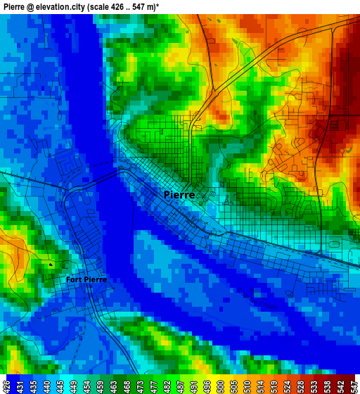
Below is the Elevation map of Pierre, which displays elevation range with different colors. Scale of the first map is from 426 to 547 m (1398 to 1795 ft) with average elevation of 460.7 meters (=1511 ft) [note 1]
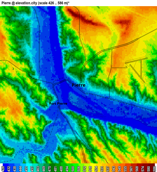
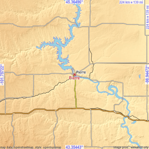
These maps also provides idea of topography and contour of this city, they are displayed at different zoom levels. More info about maps, scale and edge coordinates you can find below images.
| \ | Map #1 | Map #2 | Topo.Map |
| Scale [m] | 426..547 m | 426..586 m | × |
| Scale [ft] | 1398..1795 ft | 1398..1923 ft | × |
| Average | 460.7 m = 1511 ft | 484.1 m = 1588 ft | × |
| Width | 6.99 km = 4.3 mi | 13.97 km = 8.7 mi | 223.5 km = 138.9 mi |
| Height | 6.99 km = 4.3 mi | 13.97 km = 8.7 mi | 223.5 km = 138.9 mi |
| ↑Max Latitude | 44.399726° | 44.431116° | 45.36496° |
| Latitude at center | 44.36832° | 44.36832° | 44.36832° |
| ↓Min Latitude | 44.336897° | 44.305457° | 43.35443° |
| ← Min Longitude | -100.394915° | -100.438861° | -101.75722° |
| Longitude center | -100.35097° | -100.35097° | -100.35097° |
| →Max Longitude | -100.307025° | -100.263079° | -98.94472° |
Nearby cities:
Cities around Pierre sort by population:
• Chamberlain elevation 428 m
102.4 km,  127°
127°
• Fort Pierre 436 m
2.4 km,  227°
227°
• North Eagle Butte 735 m
99.3 km,  315°
315°
• Miller 479 m
109.4 km,  81°
81°
• Eagle Butte 736 m
99.2 km, 315°
• Fort Thompson 439 m
80 km,  114°
114°
• Gettysburg 629 m
78.1 km,  23°
23°
• Highmore 572 m
74.2 km, 76°
• Onida 568 m
44.3 km,  31°
31°
• White River 651 m
94.4 km,  199°
199°
• Murdo 704 m
60.7 km,  208°
208°
• Kennebec 514 m
64.8 km,  142°
142°
Multilingual:
 En español:
Pierre elevación 450 m.
 En France:
Pierre élévation 450 m.


Sources and notes:
- [note 1] Map square and city borders are not equal. Map elevation data is calculated only from area inside that square.
- [src 1] Elevation data from geonames database provided with same terms of usage.
- [src 2] The elevation map of Pierre is generated using elevation data from NASA's 3 arcsec (90m) resolution SRTM data.
- [src 3] Base (background) map © OpenStreetMap contributors tiles are generated by Geofabrik and OpenTopoMap.
Copyright & License:
This Pierre Elevation Map is licensed under CC BY-SA. You may reuse any part from this page, if you give a proper credit by linking to this URL:
 More info on terms of use page.