Ogallala elevation
Ogallala (Nebraska, Keith County), United States elevation is 985 meters and Ogallala elevation in feet is 3232 ft above sea level [src 1]. Ogallala is a seat of a second-order administrative division (feature code) with elevation that is 706 meters (2316 ft) bigger than average city elevation in United States.
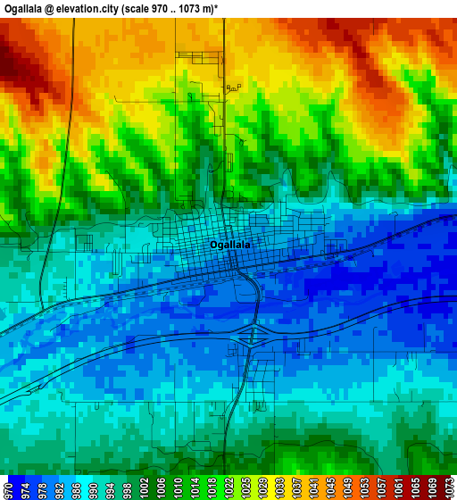
Below is the Elevation map of Ogallala, which displays elevation range with different colors. Scale of the first map is from 970 to 1073 m (3182 to 3520 ft) with average elevation of 1004 meters (=3294 ft) [note 1]
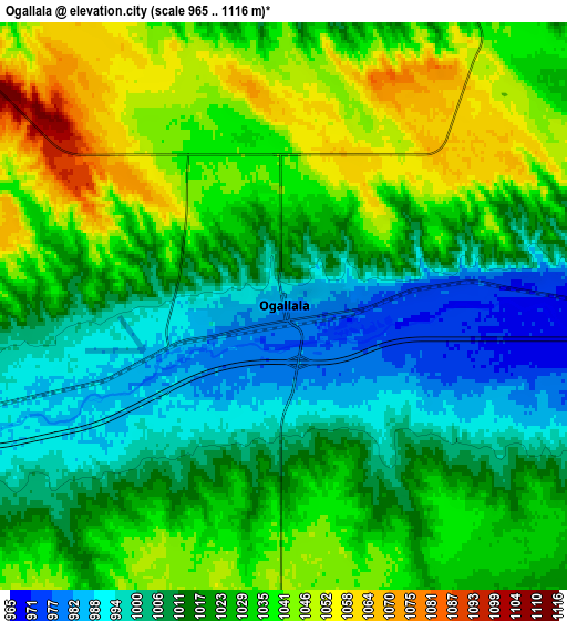
These maps also provides idea of topography and contour of this city, they are displayed at different zoom levels. More info about maps, scale and edge coordinates you can find below images.
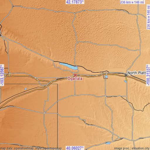
| \ | Map #1 | Map #2 | Topo.Map |
| Scale [m] | 970..1073 m | 965..1116 m | × |
| Scale [ft] | 3182..3520 ft | 3166..3661 ft | × |
| Average | 1004 m = 3294 ft | 1022.8 m = 3356 ft | × |
| Width | 7.36 km = 4.6 mi | 14.72 km = 9.1 mi | 235.6 km = 146.4 mi |
| Height | 7.36 km = 4.6 mi | 14.72 km = 9.1 mi | 235.5 km = 146.3 mi |
| ↑Max Latitude | 41.161143° | 41.194219° | 42.17873° |
| Latitude at center | 41.12805° | 41.12805° | 41.12805° |
| ↓Min Latitude | 41.09494° | 41.061814° | 40.06027° |
| ← Min Longitude | -101.763565° | -101.807511° | -103.12587° |
| Longitude center | -101.71962° | -101.71962° | -101.71962° |
| →Max Longitude | -101.675675° | -101.631729° | -100.31337° |
Nearby cities:
Cities around Ogallala sort by population:
• North Platte elevation 856 m
79.9 km,  90°
90°
• Holyoke 1139 m
77.8 km,  219°
219°
• Imperial 1003 m
68.3 km,  174°
174°
• Sutherland 904 m
49.8 km, 86°
• Julesburg 1062 m
48.2 km,  251°
251°
• Grant 1042 m
31.8 km,  180°
180°
• Chappell 1128 m
63 km,  266°
266°
• Oshkosh 1035 m
60.6 km,  300°
300°
• Hayes Center 936 m
90.4 km,  139°
139°
• Hyannis 1144 m
97.1 km,  357°
357°
• Tryon 998 m
79.2 km,  53°
53°
• Arthur 1112 m
49.4 km,  2°
2°
Multilingual:
 En español:
Ogallala elevación 985 m.
 En France:
Ogallala élévation 985 m.
 Auf Deutsch:
Ogallala höhe über dem Meeresspiegel ist 985 m.

Sources and notes:
- [note 1] Map square and city borders are not equal. Map elevation data is calculated only from area inside that square.
- [src 1] Elevation data from geonames database provided with same terms of usage.
- [src 2] The elevation map of Ogallala is generated using elevation data from NASA's 3 arcsec (90m) resolution SRTM data.
- [src 3] Base (background) map © OpenStreetMap contributors tiles are generated by Geofabrik and OpenTopoMap.
Copyright & License:
This Ogallala Elevation Map is licensed under CC BY-SA. You may reuse any part from this page, if you give a proper credit by linking to this URL:
 More info on terms of use page.