Grant elevation
Grant (Nebraska, Perkins County), United States elevation is 1042 meters and Grant elevation in feet is 3419 ft above sea level [src 1]. Grant is a seat of a second-order administrative division (feature code) with elevation that is 763 meters (2503 ft) bigger than average city elevation in United States.
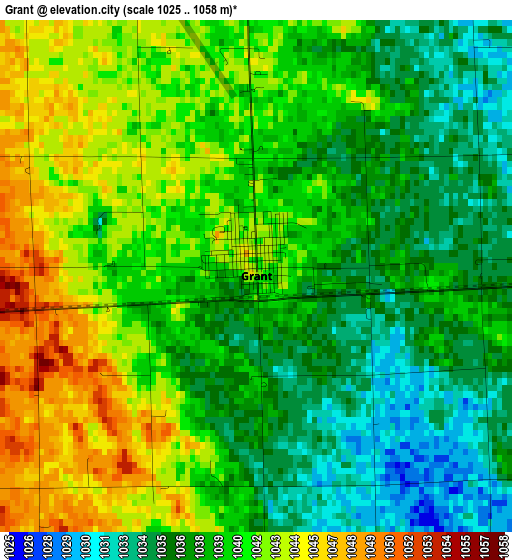
Below is the Elevation map of Grant, which displays elevation range with different colors. Scale of the first map is from 1025 to 1058 m (3363 to 3471 ft) with average elevation of 1039.2 meters (=3409 ft) [note 1]
These maps also provides idea of topography and contour of this city, they are displayed at different zoom levels. More info about maps, scale and edge coordinates you can find below images.
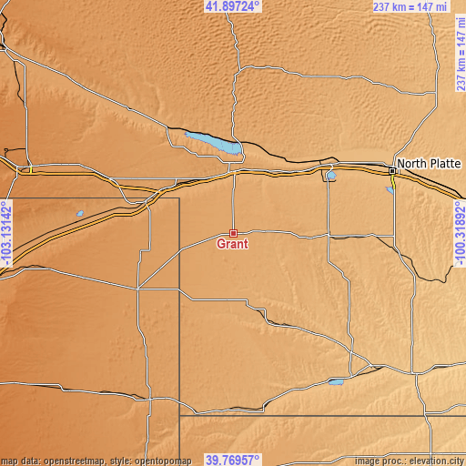
| \ | Map #1 | Topo.Map |
| Scale [m] | 1025..1058 m | × |
| Scale [ft] | 3363..3471 ft | × |
| Average | 1039.2 m = 3409 ft | × |
| Width | 7.39 km = 4.6 mi | 236.6 km = 147 mi |
| Height | 7.39 km = 4.6 mi | 236.6 km = 147 mi |
| ↑Max Latitude | 40.875177° | 41.89724° |
| Latitude at center | 40.84194° | 40.84194° |
| ↓Min Latitude | 40.808686° | 39.76957° |
| ← Min Longitude | -101.769115° | -103.13142° |
| Longitude center | -101.72517° | -101.72517° |
| →Max Longitude | -101.681225° | -100.31892° |
Nearby cities:
Cities around Grant sort by population:
• North Platte elevation 856 m
86.4 km,  68°
68°
• Ogallala 985 m
31.8 km,  0°
0°
• Wray 1090 m
95 km,  206°
206°
• Holyoke 1139 m
56.4 km,  239°
239°
• Imperial 1003 m
36.8 km,  169°
169°
• Sutherland 904 m
61.3 km,  55°
55°
• Julesburg 1062 m
48.1 km,  289°
289°
• Chappell 1128 m
68.5 km, 294°
• Benkelman 913 m
89.6 km, 169°
• Oshkosh 1035 m
81.3 km,  320°
320°
• Hayes Center 936 m
70 km,  121°
121°
• Arthur 1112 m
81.2 km, 1°
Multilingual:
 En español:
Grant elevación 1042 m.
 En France:
Grant élévation 1042 m.


Sources and notes:
- [note 1] Map square and city borders are not equal. Map elevation data is calculated only from area inside that square.
- [src 1] Elevation data from geonames database provided with same terms of usage.
- [src 2] The elevation map of Grant is generated using elevation data from NASA's 3 arcsec (90m) resolution SRTM data.
- [src 3] Base (background) map © OpenStreetMap contributors tiles are generated by Geofabrik and OpenTopoMap.
Copyright & License:
This Grant Elevation Map is licensed under CC BY-SA. You may reuse any part from this page, if you give a proper credit by linking to this URL:
 More info on terms of use page.