Gering elevation
Gering (Nebraska, Scotts Bluff County), United States elevation is 1194 meters and Gering elevation in feet is 3917 ft above sea level [src 1]. Gering is a seat of a second-order administrative division (feature code) with elevation that is 915 meters (3002 ft) bigger than average city elevation in United States.
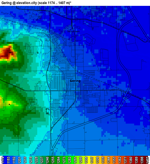
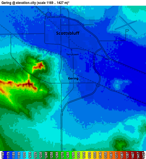
Below is the Elevation map of Gering, which displays elevation range with different colors. Scale of the first map is from 1174 to 1407 m (3852 to 4616 ft) with average elevation of 1201.3 meters (=3941 ft) [note 1]
These maps also provides idea of topography and contour of this city, they are displayed at different zoom levels. More info about maps, scale and edge coordinates you can find below images.
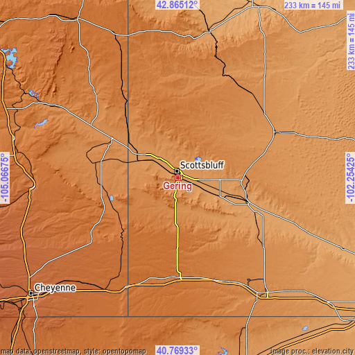
| \ | Map #1 | Map #2 | Topo.Map |
| Scale [m] | 1174..1407 m | 1169..1427 m | × |
| Scale [ft] | 3852..4616 ft | 3835..4682 ft | × |
| Average | 1201.3 m = 3941 ft | 1208.6 m = 3965 ft | × |
| Width | 7.28 km = 4.5 mi | 14.56 km = 9 mi | 233 km = 144.8 mi |
| Height | 7.28 km = 4.5 mi | 14.56 km = 9 mi | 233 km = 144.8 mi |
| ↑Max Latitude | 41.858539° | 41.89126° | 42.86512° |
| Latitude at center | 41.8258° | 41.8258° | 41.8258° |
| ↓Min Latitude | 41.793045° | 41.760273° | 40.76933° |
| ← Min Longitude | -103.704445° | -103.748391° | -105.06675° |
| Longitude center | -103.6605° | -103.6605° | -103.6605° |
| →Max Longitude | -103.616555° | -103.572609° | -102.25425° |
Nearby cities:
Cities around Gering sort by population:
• Scottsbluff elevation 1187 m
4.6 km,  353°
353°
• Alliance 1214 m
72 km,  64°
64°
• Sidney 1246 m
94.9 km,  143°
143°
• Torrington 1251 m
50.7 km,  301°
301°
• Kimball 1439 m
65.6 km,  180°
180°
• Mitchell 1203 m
17.7 km,  316°
316°
• Bridgeport 1121 m
49.9 km,  110°
110°
• Terrytown 1183 m
2.4 km,  357°
357°
• Bayard 1148 m
29 km, 105°
• Pine Bluffs 1539 m
79.3 km,  205°
205°
• Harrison 1485 m
97.5 km, 349°
• Harrisburg 1368 m
30.7 km,  192°
192°
Multilingual:
 En español:
Gering elevación 1194 m.
 En France:
Gering élévation 1194 m.


Sources and notes:
- [note 1] Map square and city borders are not equal. Map elevation data is calculated only from area inside that square.
- [src 1] Elevation data from geonames database provided with same terms of usage.
- [src 2] The elevation map of Gering is generated using elevation data from NASA's 3 arcsec (90m) resolution SRTM data.
- [src 3] Base (background) map © OpenStreetMap contributors tiles are generated by Geofabrik and OpenTopoMap.
Copyright & License:
This Gering Elevation Map is licensed under CC BY-SA. You may reuse any part from this page, if you give a proper credit by linking to this URL:
 More info on terms of use page.