Greeley elevation
Greeley (Colorado, Weld County), United States elevation is 1428 meters and Greeley elevation in feet is 4685 ft above sea level [src 1]. Greeley is a seat of a second-order administrative division (feature code) with elevation that is 1149 meters (3770 ft) bigger than average city elevation in United States.
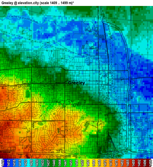
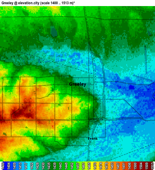
Below is the Elevation map of Greeley, which displays elevation range with different colors. Scale of the first map is from 1409 to 1499 m (4623 to 4918 ft) with average elevation of 1438.4 meters (=4719 ft) [note 1]
These maps also provides idea of topography and contour of this city, they are displayed at different zoom levels. More info about maps, scale and edge coordinates you can find below images.
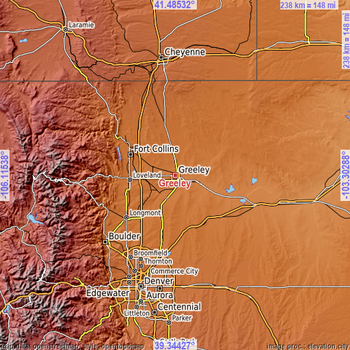
| \ | Map #1 | Map #2 | Topo.Map |
| Scale [m] | 1409..1499 m | 1400..1513 m | × |
| Scale [ft] | 4623..4918 ft | 4593..4964 ft | × |
| Average | 1438.4 m = 4719 ft | 1439.8 m = 4724 ft | × |
| Width | 7.44 km = 4.6 mi | 14.88 km = 9.2 mi | 238.1 km = 147.9 mi |
| Height | 7.44 km = 4.6 mi | 14.88 km = 9.2 mi | 238.1 km = 147.9 mi |
| ↑Max Latitude | 40.456756° | 40.490186° | 41.48532° |
| Latitude at center | 40.42331° | 40.42331° | 40.42331° |
| ↓Min Latitude | 40.389847° | 40.356368° | 39.34427° |
| ← Min Longitude | -104.753075° | -104.797021° | -106.11538° |
| Longitude center | -104.70913° | -104.70913° | -104.70913° |
| →Max Longitude | -104.665185° | -104.621239° | -103.30288° |
Nearby cities:
Cities around Greeley sort by population:
• Loveland elevation 1522 m
31.1 km,  264°
264°
• Windsor 1468 m
17.3 km,  290°
290°
• Evans 1422 m
5.4 km,  164°
164°
• Johnstown 1486 m
19.7 km,  240°
240°
• Milliken 1452 m
16.2 km,  229°
229°
• Eaton 1476 m
11.9 km,  359°
359°
• Severance 1494 m
16.4 km,  313°
313°
• Platteville 1472 m
25.1 km,  202°
202°
• La Salle 1429 m
8.3 km,  175°
175°
• Ault 1508 m
17.8 km,  353°
353°
• Kersey 1409 m
13.1 km,  107°
107°
• Gilcrest 1450 m
16.8 km, 200°
Multilingual:
 En español:
Greeley elevación 1428 m.
 En France:
Greeley élévation 1428 m.
 Auf Deutsch:
Greeley höhe über dem Meeresspiegel ist 1428 m.

Sources and notes:
- [note 1] Map square and city borders are not equal. Map elevation data is calculated only from area inside that square.
- [src 1] Elevation data from geonames database provided with same terms of usage.
- [src 2] The elevation map of Greeley is generated using elevation data from NASA's 3 arcsec (90m) resolution SRTM data.
- [src 3] Base (background) map © OpenStreetMap contributors tiles are generated by Geofabrik and OpenTopoMap.
Copyright & License:
This Greeley Elevation Map is licensed under CC BY-SA. You may reuse any part from this page, if you give a proper credit by linking to this URL:
 More info on terms of use page.