Loveland elevation
Loveland (Colorado, Larimer County), United States elevation is 1522 meters and Loveland elevation in feet is 4993 ft above sea level [src 1]. Loveland is a populated place (feature code) with elevation that is 1243 meters (4078 ft) bigger than average city elevation in United States.
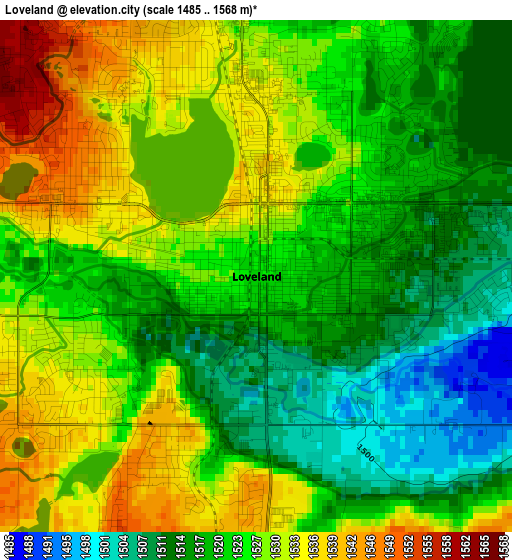
Below is the Elevation map of Loveland, which displays elevation range with different colors. Scale of the first map is from 1485 to 1568 m (4872 to 5144 ft) with average elevation of 1523.9 meters (=5000 ft) [note 1]
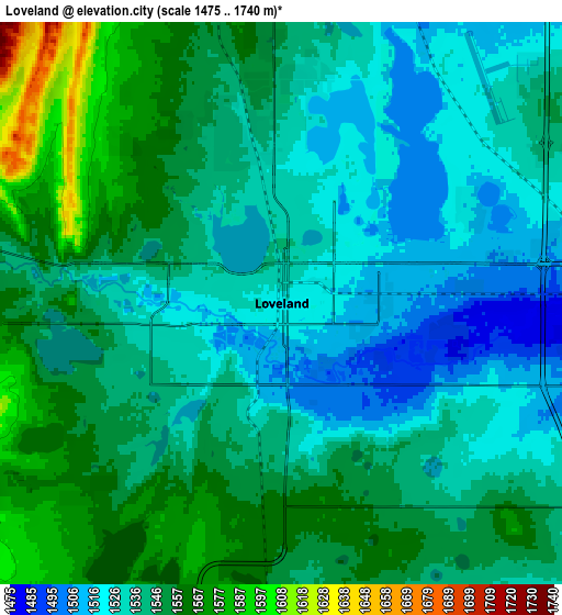
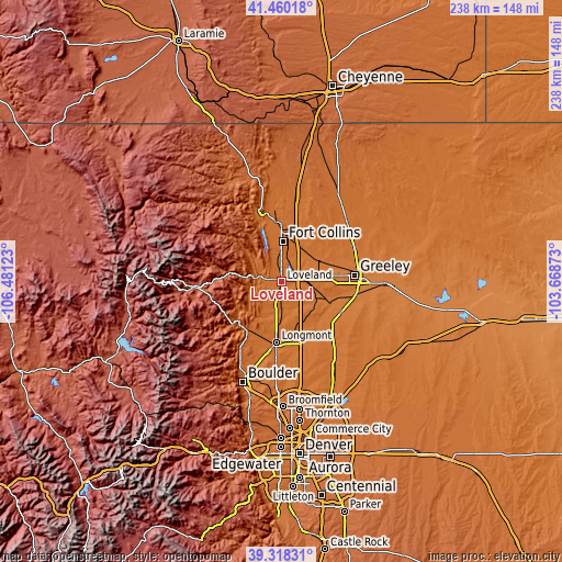
These maps also provides idea of topography and contour of this city, they are displayed at different zoom levels. More info about maps, scale and edge coordinates you can find below images.
| \ | Map #1 | Map #2 | Topo.Map |
| Scale [m] | 1485..1568 m | 1475..1740 m | × |
| Scale [ft] | 4872..5144 ft | 4839..5709 ft | × |
| Average | 1523.9 m = 5000 ft | 1543 m = 5062 ft | × |
| Width | 7.44 km = 4.6 mi | 14.88 km = 9.2 mi | 238.2 km = 148 mi |
| Height | 7.44 km = 4.6 mi | 14.88 km = 9.2 mi | 238.1 km = 147.9 mi |
| ↑Max Latitude | 40.431219° | 40.464661° | 41.46018° |
| Latitude at center | 40.39776° | 40.39776° | 40.39776° |
| ↓Min Latitude | 40.364285° | 40.330792° | 39.31831° |
| ← Min Longitude | -105.118925° | -105.162871° | -106.48123° |
| Longitude center | -105.07498° | -105.07498° | -105.07498° |
| →Max Longitude | -105.031035° | -104.987089° | -103.66873° |
Nearby cities:
Cities around Loveland sort by population:
• Fort Collins elevation 1531 m
20.9 km,  357°
357°
• Longmont 1520 m
25.7 km,  185°
185°
• Windsor 1468 m
17.2 km,  58°
58°
• Johnstown 1486 m
15.4 km,  116°
116°
• Milliken 1452 m
20.1 km,  112°
112°
• Berthoud 1540 m
10 km,  182°
182°
• Mead 1528 m
19.4 km,  160°
160°
• Severance 1494 m
23.6 km,  53°
53°
• Laporte 1546 m
26 km,  347°
347°
• Lyons 1643 m
25.4 km,  220°
220°
• Campion 1564 m
5.4 km, 182°
• Gilcrest 1450 m
28.3 km, 117°
Multilingual:
 En español:
Loveland elevación 1522 m.
 En France:
Loveland élévation 1522 m.
 Auf Deutsch:
Loveland höhe über dem Meeresspiegel ist 1522 m.

Sources and notes:
- [note 1] Map square and city borders are not equal. Map elevation data is calculated only from area inside that square.
- [src 1] Elevation data from geonames database provided with same terms of usage.
- [src 2] The elevation map of Loveland is generated using elevation data from NASA's 3 arcsec (90m) resolution SRTM data.
- [src 3] Base (background) map © OpenStreetMap contributors tiles are generated by Geofabrik and OpenTopoMap.
Copyright & License:
This Loveland Elevation Map is licensed under CC BY-SA. You may reuse any part from this page, if you give a proper credit by linking to this URL:
 More info on terms of use page.