Mount Shasta elevation
Mount Shasta (California, Siskiyou County), United States elevation is 1089 meters and Mount Shasta elevation in feet is 3573 ft above sea level [src 1]. Mount Shasta is a populated place (feature code) with elevation that is 810 meters (2657 ft) bigger than average city elevation in United States.
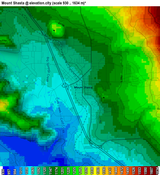
Below is the Elevation map of Mount Shasta, which displays elevation range with different colors. Scale of the first map is from 930 to 1634 m (3051 to 5361 ft) with average elevation of 1145.6 meters (=3759 ft) [note 1]
These maps also provides idea of topography and contour of this city, they are displayed at different zoom levels. More info about maps, scale and edge coordinates you can find below images.
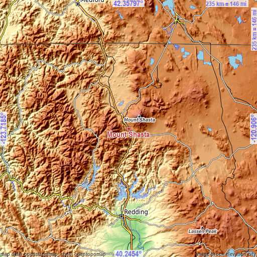
| \ | Map #1 | Topo.Map |
| Scale [m] | 930..1634 m | × |
| Scale [ft] | 3051..5361 ft | × |
| Average | 1145.6 m = 3759 ft | × |
| Width | 7.34 km = 4.6 mi | 234.9 km = 146 mi |
| Height | 7.34 km = 4.6 mi | 234.9 km = 146 mi |
| ↑Max Latitude | 41.343241° | 42.35797° |
| Latitude at center | 41.31024° | 41.31024° |
| ↓Min Latitude | 41.277222° | 40.2454° |
| ← Min Longitude | -122.356195° | -123.7185° |
| Longitude center | -122.31225° | -122.31225° |
| →Max Longitude | -122.268305° | -120.906° |
Nearby cities:
Cities around Mount Shasta sort by population:
• Redding elevation 172 m
80.7 km,  184°
184°
• Shasta Lake 252 m
70.2 km, 184°
• Yreka 793 m
54.4 km,  330°
330°
• Central Valley (historical) 252 m
70.2 km, 184°
• Burney 955 m
72.4 km,  131°
131°
• Bella Vista 176 m
74.7 km,  174°
174°
• Weed 1051 m
13.9 km, 333°
• Shasta 322 m
80.5 km,  190°
190°
• Dunsmuir 696 m
11.8 km,  163°
163°
• Montague 775 m
49.8 km,  338°
338°
• Lewiston 557 m
78.9 km,  211°
211°
• McCloud 1001 m
15.7 km,  112°
112°
Multilingual:
 En español:
Mount Shasta elevación 1089 m.
 En France:
Mount Shasta élévation 1089 m.
 Auf Deutsch:
Mount Shasta höhe über dem Meeresspiegel ist 1089 m.

Sources and notes:
- [note 1] Map square and city borders are not equal. Map elevation data is calculated only from area inside that square.
- [src 1] Elevation data from geonames database provided with same terms of usage.
- [src 2] The elevation map of Mount Shasta is generated using elevation data from NASA's 3 arcsec (90m) resolution SRTM data.
- [src 3] Base (background) map © OpenStreetMap contributors tiles are generated by Geofabrik and OpenTopoMap.
Copyright & License:
This Mount Shasta Elevation Map is licensed under CC BY-SA. You may reuse any part from this page, if you give a proper credit by linking to this URL:
 More info on terms of use page.