Centerfield elevation
Centerfield (Utah, Sanpete County), United States elevation is 1555 meters and Centerfield elevation in feet is 5102 ft above sea level [src 1]. Centerfield is a populated place (feature code) with elevation that is 1276 meters (4186 ft) bigger than average city elevation in United States.
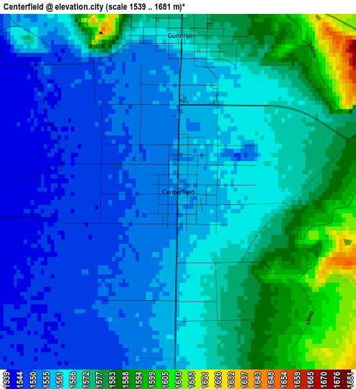
Below is the Elevation map of Centerfield, which displays elevation range with different colors. Scale of the first map is from 1539 to 1681 m (5049 to 5515 ft) with average elevation of 1565.6 meters (=5136 ft) [note 1]
These maps also provides idea of topography and contour of this city, they are displayed at different zoom levels. More info about maps, scale and edge coordinates you can find below images.
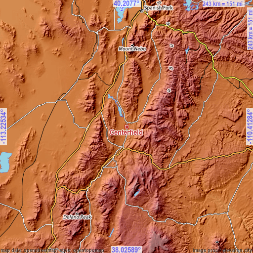
| \ | Map #1 | Topo.Map |
| Scale [m] | 1539..1681 m | × |
| Scale [ft] | 5049..5515 ft | × |
| Average | 1565.6 m = 5136 ft | × |
| Width | 7.58 km = 4.7 mi | 242.6 km = 150.7 mi |
| Height | 7.58 km = 4.7 mi | 242.6 km = 150.7 mi |
| ↑Max Latitude | 39.159323° | 40.2077° |
| Latitude at center | 39.12524° | 39.12524° |
| ↓Min Latitude | 39.09114° | 38.02589° |
| ← Min Longitude | -111.863035° | -113.22534° |
| Longitude center | -111.81909° | -111.81909° |
| →Max Longitude | -111.775145° | -110.41284° |
Nearby cities:
Cities around Centerfield sort by population:
• Richfield elevation 1636 m
45.4 km,  210°
210°
• Ephraim 1693 m
32.9 km,  37°
37°
• Manti 1714 m
22.4 km, 44°
• Mount Pleasant 1809 m
56.4 km,  33°
33°
• Gunnison 1567 m
3.3 km,  1°
1°
• Salina 1576 m
19 km,  190°
190°
• Fillmore 1566 m
46.9 km,  248°
248°
• Ferron 1822 m
59.3 km,  93°
93°
• Moroni 1686 m
48.6 km,  23°
23°
• Fountain Green 1803 m
58.3 km, 15°
• Aurora 1586 m
24.7 km,  203°
203°
• Spring City 1778 m
48.5 km, 34°
Multilingual:
 En español:
Centerfield elevación 1555 m.
 En France:
Centerfield élévation 1555 m.
 Auf Deutsch:
Centerfield höhe über dem Meeresspiegel ist 1555 m.

Sources and notes:
- [note 1] Map square and city borders are not equal. Map elevation data is calculated only from area inside that square.
- [src 1] Elevation data from geonames database provided with same terms of usage.
- [src 2] The elevation map of Centerfield is generated using elevation data from NASA's 3 arcsec (90m) resolution SRTM data.
- [src 3] Base (background) map © OpenStreetMap contributors tiles are generated by Geofabrik and OpenTopoMap.
Copyright & License:
This Centerfield Elevation Map is licensed under CC BY-SA. You may reuse any part from this page, if you give a proper credit by linking to this URL:
 More info on terms of use page.