Stratford elevation
Stratford (Texas, Sherman County), United States elevation is 1128 meters and Stratford elevation in feet is 3701 ft above sea level [src 1]. Stratford is a seat of a second-order administrative division (feature code) with elevation that is 849 meters (2785 ft) bigger than average city elevation in United States.
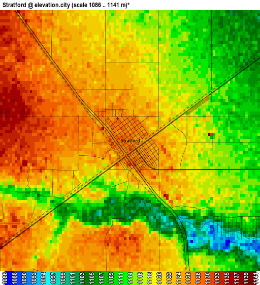
Below is the Elevation map of Stratford, which displays elevation range with different colors. Scale of the first map is from 1086 to 1141 m (3563 to 3743 ft) with average elevation of 1119.2 meters (=3672 ft) [note 1]
These maps also provides idea of topography and contour of this city, they are displayed at different zoom levels. More info about maps, scale and edge coordinates you can find below images.
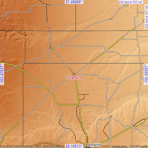
| \ | Map #1 | Topo.Map |
| Scale [m] | 1086..1141 m | × |
| Scale [ft] | 3563..3743 ft | × |
| Average | 1119.2 m = 3672 ft | × |
| Width | 7.87 km = 4.9 mi | 251.9 km = 156.5 mi |
| Height | 7.87 km = 4.9 mi | 251.9 km = 156.5 mi |
| ↑Max Latitude | 36.371532° | 37.46068° |
| Latitude at center | 36.33614° | 36.33614° |
| ↓Min Latitude | 36.300732° | 35.19513° |
| ← Min Longitude | -102.116065° | -103.47837° |
| Longitude center | -102.07212° | -102.07212° |
| →Max Longitude | -102.028175° | -100.66587° |
Nearby cities:
Cities around Stratford sort by population:
• Dumas elevation 1118 m
53.1 km,  170°
170°
• Guymon 954 m
65.4 km,  53°
53°
• Dalhart 1215 m
50.1 km,  232°
232°
• Spearman 954 m
80.3 km,  100°
100°
• Cactus 1106 m
32.2 km, 168°
• Elkhart 1091 m
76.5 km,  12°
12°
• Sunray 1070 m
41.9 km,  147°
147°
• Stinnett 978 m
80 km,  135°
135°
• Goodwell 1009 m
48.4 km, 53°
• Gruver 977 m
60.2 km, 97°
• Boise City 1272 m
58.9 km,  317°
317°
• Channing 1161 m
76.2 km,  197°
197°
Multilingual:
 En español:
Stratford elevación 1128 m.
 En France:
Stratford élévation 1128 m.
 Auf Deutsch:
Stratford höhe über dem Meeresspiegel ist 1128 m.

Sources and notes:
- [note 1] Map square and city borders are not equal. Map elevation data is calculated only from area inside that square.
- [src 1] Elevation data from geonames database provided with same terms of usage.
- [src 2] The elevation map of Stratford is generated using elevation data from NASA's 3 arcsec (90m) resolution SRTM data.
- [src 3] Base (background) map © OpenStreetMap contributors tiles are generated by Geofabrik and OpenTopoMap.
Copyright & License:
This Stratford Elevation Map is licensed under CC BY-SA. You may reuse any part from this page, if you give a proper credit by linking to this URL:
 More info on terms of use page.