Stinnett elevation
Stinnett (Texas, Hutchinson County), United States elevation is 978 meters and Stinnett elevation in feet is 3209 ft above sea level [src 1]. Stinnett is a seat of a second-order administrative division (feature code) with elevation that is 699 meters (2293 ft) bigger than average city elevation in United States.
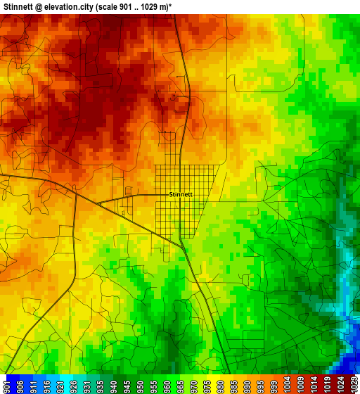
Below is the Elevation map of Stinnett, which displays elevation range with different colors. Scale of the first map is from 901 to 1029 m (2956 to 3376 ft) with average elevation of 977.8 meters (=3208 ft) [note 1]
These maps also provides idea of topography and contour of this city, they are displayed at different zoom levels. More info about maps, scale and edge coordinates you can find below images.
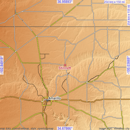
| \ | Map #1 | Topo.Map |
| Scale [m] | 901..1029 m | × |
| Scale [ft] | 2956..3376 ft | × |
| Average | 977.8 m = 3208 ft | × |
| Width | 7.92 km = 4.9 mi | 253.5 km = 157.5 mi |
| Height | 7.92 km = 4.9 mi | 253.5 km = 157.5 mi |
| ↑Max Latitude | 35.862602° | 36.95893° |
| Latitude at center | 35.82698° | 35.82698° |
| ↓Min Latitude | 35.791342° | 34.67866° |
| ← Min Longitude | -101.486885° | -102.84919° |
| Longitude center | -101.44294° | -101.44294° |
| →Max Longitude | -101.398995° | -100.03669° |
Nearby cities:
Cities around Stinnett sort by population:
• Amarillo elevation 1124 m
75.9 km,  207°
207°
• Pampa 991 m
54.3 km,  126°
126°
• Dumas 1118 m
48 km,  275°
275°
• Borger 944 m
18.2 km,  166°
166°
• Spearman 954 m
47 km,  28°
28°
• Cactus 1106 m
56.2 km,  296°
296°
• Panhandle 1057 m
53.8 km, 173°
• Fritch 980 m
25.3 km, 214°
• Sunray 1070 m
40.3 km, 301°
• Claude 1039 m
79.9 km, 174°
• Gruver 977 m
48.8 km,  3°
3°
• Miami 840 m
74.2 km,  101°
101°
Multilingual:
 En español:
Stinnett elevación 978 m.
 En France:
Stinnett élévation 978 m.
 Auf Deutsch:
Stinnett höhe über dem Meeresspiegel ist 978 m.

Sources and notes:
- [note 1] Map square and city borders are not equal. Map elevation data is calculated only from area inside that square.
- [src 1] Elevation data from geonames database provided with same terms of usage.
- [src 2] The elevation map of Stinnett is generated using elevation data from NASA's 3 arcsec (90m) resolution SRTM data.
- [src 3] Base (background) map © OpenStreetMap contributors tiles are generated by Geofabrik and OpenTopoMap.
Copyright & License:
This Stinnett Elevation Map is licensed under CC BY-SA. You may reuse any part from this page, if you give a proper credit by linking to this URL:
 More info on terms of use page.