Post elevation
Post (Texas, Garza County), United States elevation is 795 meters and Post elevation in feet is 2608 ft above sea level [src 1]. Post is a seat of a second-order administrative division (feature code) with elevation that is 516 meters (1693 ft) bigger than average city elevation in United States.
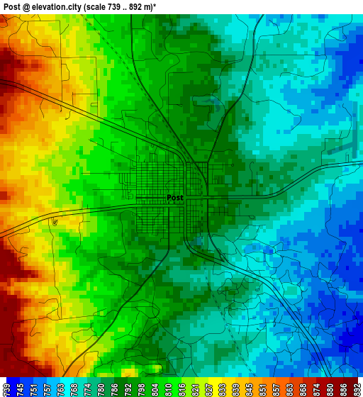
Below is the Elevation map of Post, which displays elevation range with different colors. Scale of the first map is from 739 to 892 m (2425 to 2927 ft) with average elevation of 795.8 meters (=2611 ft) [note 1]
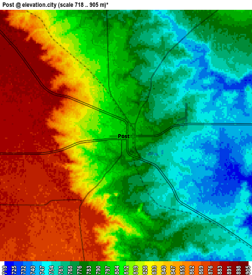
These maps also provides idea of topography and contour of this city, they are displayed at different zoom levels. More info about maps, scale and edge coordinates you can find below images.
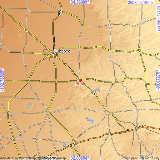
| \ | Map #1 | Map #2 | Topo.Map |
| Scale [m] | 739..892 m | 718..905 m | × |
| Scale [ft] | 2425..2927 ft | 2356..2969 ft | × |
| Average | 795.8 m = 2611 ft | 805.7 m = 2643 ft | × |
| Width | 8.18 km = 5.1 mi | 16.36 km = 10.2 mi | 261.7 km = 162.6 mi |
| Height | 8.18 km = 5.1 mi | 16.36 km = 10.2 mi | 261.7 km = 162.6 mi |
| ↑Max Latitude | 33.227988° | 33.26474° | 34.36009° |
| Latitude at center | 33.19122° | 33.19122° | 33.19122° |
| ↓Min Latitude | 33.154437° | 33.117638° | 32.00654° |
| ← Min Longitude | -101.422945° | -101.466891° | -102.78525° |
| Longitude center | -101.379° | -101.379° | -101.379° |
| →Max Longitude | -101.335055° | -101.291109° | -99.97275° |
Nearby cities:
Cities around Post sort by population:
• Lubbock elevation 979 m
61.7 km,  314°
314°
• Snyder 709 m
68 km,  140°
140°
• Slaton 942 m
36.8 km,  318°
318°
• Wolfforth 1012 m
68.2 km,  300°
300°
• Tahoka 944 m
38.7 km,  265°
265°
• Idalou 979 m
59.9 km,  331°
331°
• Ralls 950 m
53.7 km,  359°
359°
• Crosbyton 923 m
53.8 km,  14°
14°
• Spur 701 m
58 km,  56°
56°
• Lorenzo 970 m
55.2 km,  344°
344°
• Ransom Canyon 945 m
47.2 km, 323°
• Gail 779 m
47.2 km,  187°
187°
Multilingual:
 En español:
Post elevación 795 m.
 En France:
Post élévation 795 m.


Sources and notes:
- [note 1] Map square and city borders are not equal. Map elevation data is calculated only from area inside that square.
- [src 1] Elevation data from geonames database provided with same terms of usage.
- [src 2] The elevation map of Post is generated using elevation data from NASA's 3 arcsec (90m) resolution SRTM data.
- [src 3] Base (background) map © OpenStreetMap contributors tiles are generated by Geofabrik and OpenTopoMap.
Copyright & License:
This Post Elevation Map is licensed under CC BY-SA. You may reuse any part from this page, if you give a proper credit by linking to this URL:
 More info on terms of use page.