Wolfforth elevation
Wolfforth (Texas, Lubbock County), United States elevation is 1012 meters and Wolfforth elevation in feet is 3320 ft above sea level [src 1]. Wolfforth is a populated place (feature code) with elevation that is 733 meters (2405 ft) bigger than average city elevation in United States.
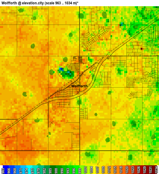
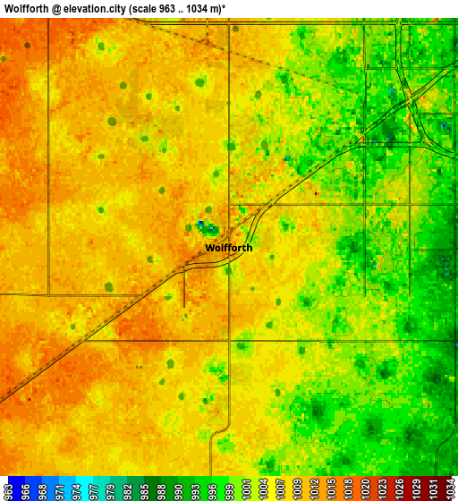
Below is the Elevation map of Wolfforth, which displays elevation range with different colors. Scale of the first map is from 963 to 1034 m (3159 to 3392 ft) with average elevation of 1007.4 meters (=3305 ft) [note 1]
These maps also provides idea of topography and contour of this city, they are displayed at different zoom levels. More info about maps, scale and edge coordinates you can find below images.
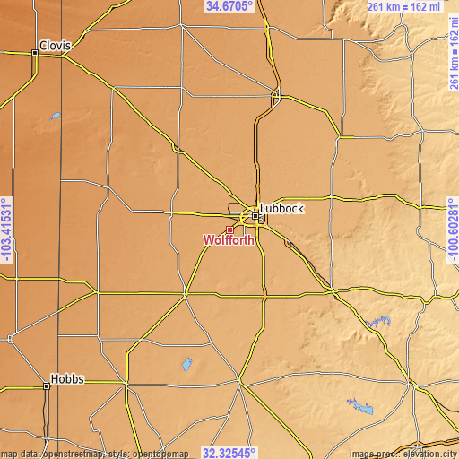
| \ | Map #1 | Map #2 | Topo.Map |
| Scale [m] | 963..1034 m | 963..1034 m | × |
| Scale [ft] | 3159..3392 ft | 3159..3392 ft | × |
| Average | 1007.4 m = 3305 ft | 1005.6 m = 3299 ft | × |
| Width | 8.15 km = 5.1 mi | 16.3 km = 10.1 mi | 260.7 km = 162 mi |
| Height | 8.15 km = 5.1 mi | 16.3 km = 10.1 mi | 260.7 km = 162 mi |
| ↑Max Latitude | 33.542555° | 33.579175° | 34.6705° |
| Latitude at center | 33.50592° | 33.50592° | 33.50592° |
| ↓Min Latitude | 33.469269° | 33.432603° | 32.32545° |
| ← Min Longitude | -102.053005° | -102.096951° | -103.41531° |
| Longitude center | -102.00906° | -102.00906° | -102.00906° |
| →Max Longitude | -101.965115° | -101.921169° | -100.60281° |
Nearby cities:
Cities around Wolfforth sort by population:
• Lubbock elevation 979 m
16.4 km,  60°
60°
• Levelland 1072 m
35.4 km,  284°
284°
• Brownfield 1010 m
43.7 km,  214°
214°
• Slaton 942 m
34.8 km,  102°
102°
• Abernathy 1026 m
39.4 km,  22°
22°
• Tahoka 944 m
42.7 km,  152°
152°
• Shallowater 1006 m
20.4 km,  2°
2°
• Idalou 979 m
35.1 km, 59°
• Sundown 1080 m
44.9 km,  262°
262°
• Lorenzo 970 m
47.6 km,  67°
67°
• Ransom Canyon 945 m
30.7 km,  84°
84°
• Anton 1029 m
36.8 km,  337°
337°
Multilingual:
 En español:
Wolfforth elevación 1012 m.
 En France:
Wolfforth élévation 1012 m.
 Auf Deutsch:
Wolfforth höhe über dem Meeresspiegel ist 1012 m.

Sources and notes:
- [note 1] Map square and city borders are not equal. Map elevation data is calculated only from area inside that square.
- [src 1] Elevation data from geonames database provided with same terms of usage.
- [src 2] The elevation map of Wolfforth is generated using elevation data from NASA's 3 arcsec (90m) resolution SRTM data.
- [src 3] Base (background) map © OpenStreetMap contributors tiles are generated by Geofabrik and OpenTopoMap.
Copyright & License:
This Wolfforth Elevation Map is licensed under CC BY-SA. You may reuse any part from this page, if you give a proper credit by linking to this URL:
 More info on terms of use page.