Mosquero elevation
Mosquero (New Mexico, Harding County), United States elevation is 1703 meters and Mosquero elevation in feet is 5587 ft above sea level [src 1]. Mosquero is a seat of a second-order administrative division (feature code) with elevation that is 1424 meters (4672 ft) bigger than average city elevation in United States.
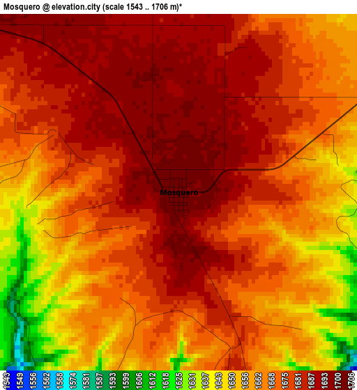
Below is the Elevation map of Mosquero, which displays elevation range with different colors. Scale of the first map is from 1543 to 1706 m (5062 to 5597 ft) with average elevation of 1671.6 meters (=5484 ft) [note 1]
These maps also provides idea of topography and contour of this city, they are displayed at different zoom levels. More info about maps, scale and edge coordinates you can find below images.
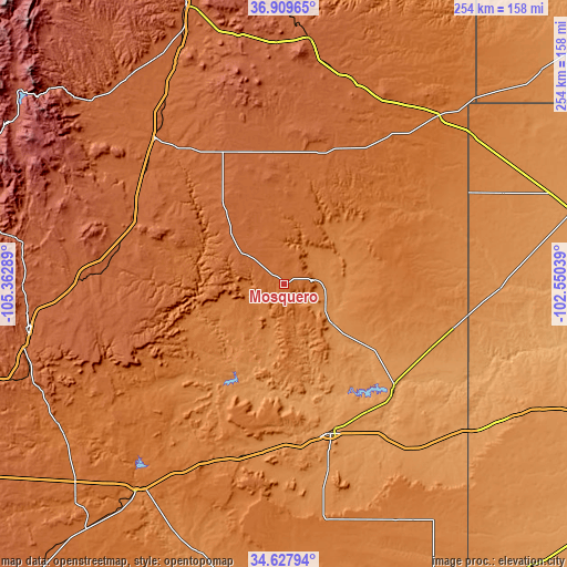
| \ | Map #1 | Topo.Map |
| Scale [m] | 1543..1706 m | × |
| Scale [ft] | 5062..5597 ft | × |
| Average | 1671.6 m = 5484 ft | × |
| Width | 7.93 km = 4.9 mi | 253.7 km = 157.6 mi |
| Height | 7.93 km = 4.9 mi | 253.7 km = 157.6 mi |
| ↑Max Latitude | 35.812625° | 36.90965° |
| Latitude at center | 35.77698° | 35.77698° |
| ↓Min Latitude | 35.741319° | 34.62794° |
| ← Min Longitude | -104.000585° | -105.36289° |
| Longitude center | -103.95664° | -103.95664° |
| →Max Longitude | -103.912695° | -102.55039° |
Nearby cities:
Cities around Mosquero sort by population:
• Las Vegas elevation 1960 m
116.2 km,  259°
259°
• Dalhart 1215 m
133.7 km,  76°
76°
• Raton 2034 m
132.5 km,  340°
340°
• Tucumcari 1250 m
70.4 km,  162°
162°
• Clayton 1542 m
102.2 km,  42°
42°
• Santa Rosa 1406 m
114.1 km,  215°
215°
• Pecos 2110 m
156.8 km, 261°
• Angel Fire 2566 m
137.6 km,  299°
299°
• Fort Sumner 1229 m
147.5 km,  190°
190°
• Vega 1236 m
150.5 km,  113°
113°
• Mora 2190 m
125.7 km,  280°
280°
• Channing 1161 m
147.2 km,  94°
94°
Multilingual:
 En español:
Mosquero elevación 1703 m.
 En France:
Mosquero élévation 1703 m.
 Auf Deutsch:
Mosquero höhe über dem Meeresspiegel ist 1703 m.

Sources and notes:
- [note 1] Map square and city borders are not equal. Map elevation data is calculated only from area inside that square.
- [src 1] Elevation data from geonames database provided with same terms of usage.
- [src 2] The elevation map of Mosquero is generated using elevation data from NASA's 3 arcsec (90m) resolution SRTM data.
- [src 3] Base (background) map © OpenStreetMap contributors tiles are generated by Geofabrik and OpenTopoMap.
Copyright & License:
This Mosquero Elevation Map is licensed under CC BY-SA. You may reuse any part from this page, if you give a proper credit by linking to this URL:
 More info on terms of use page.