McIntosh elevation
McIntosh (New Mexico, Torrance County), United States elevation is 1874 meters and McIntosh elevation in feet is 6148 ft above sea level [src 1]. McIntosh is a populated place (feature code) with elevation that is 1595 meters (5233 ft) bigger than average city elevation in United States.
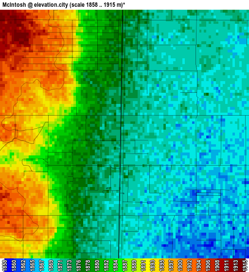
Below is the Elevation map of McIntosh, which displays elevation range with different colors. Scale of the first map is from 1858 to 1915 m (6096 to 6283 ft) with average elevation of 1878.1 meters (=6162 ft) [note 1]
These maps also provides idea of topography and contour of this city, they are displayed at different zoom levels. More info about maps, scale and edge coordinates you can find below images.
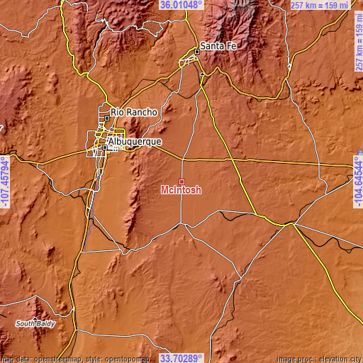
| \ | Map #1 | Topo.Map |
| Scale [m] | 1858..1915 m | × |
| Scale [ft] | 6096..6283 ft | × |
| Average | 1878.1 m = 6162 ft | × |
| Width | 8.02 km = 5 mi | 256.6 km = 159.4 mi |
| Height | 8.02 km = 5 mi | 256.6 km = 159.4 mi |
| ↑Max Latitude | 34.900829° | 36.01048° |
| Latitude at center | 34.86478° | 34.86478° |
| ↓Min Latitude | 34.828715° | 33.70289° |
| ← Min Longitude | -106.095635° | -107.45794° |
| Longitude center | -106.05169° | -106.05169° |
| →Max Longitude | -106.007745° | -104.64544° |
Nearby cities:
Cities around McIntosh sort by population:
• Meadow Lake elevation 1661 m
45.4 km,  261°
261°
• El Cerro Mission 1538 m
55.3 km, 258°
• Edgewood 2027 m
25.3 km,  329°
329°
• Peralta 1480 m
58.4 km,  266°
266°
• Sandia Heights 1866 m
53 km,  310°
310°
• Moriarty 1892 m
13.9 km,  0°
0°
• Las Maravillas 1527 m
58.1 km, 255°
• Estancia 1864 m
11.8 km,  181°
181°
• Monterey Park 1536 m
55.1 km, 257°
• Carnuel 1790 m
43.1 km,  300°
300°
• Sandia Knolls 2052 m
40.8 km,  324°
324°
• Ponderosa Pine 2296 m
27.8 km, 296°
Multilingual:
 En español:
McIntosh elevación 1874 m.
 En France:
McIntosh élévation 1874 m.
 Auf Deutsch:
McIntosh höhe über dem Meeresspiegel ist 1874 m.

Sources and notes:
- [note 1] Map square and city borders are not equal. Map elevation data is calculated only from area inside that square.
- [src 1] Elevation data from geonames database provided with same terms of usage.
- [src 2] The elevation map of McIntosh is generated using elevation data from NASA's 3 arcsec (90m) resolution SRTM data.
- [src 3] Base (background) map © OpenStreetMap contributors tiles are generated by Geofabrik and OpenTopoMap.
Copyright & License:
This McIntosh Elevation Map is licensed under CC BY-SA. You may reuse any part from this page, if you give a proper credit by linking to this URL:
 More info on terms of use page.