Grants elevation
Grants (New Mexico, Cibola County), United States elevation is 1970 meters and Grants elevation in feet is 6463 ft above sea level [src 1]. Grants is a seat of a second-order administrative division (feature code) with elevation that is 1691 meters (5548 ft) bigger than average city elevation in United States.
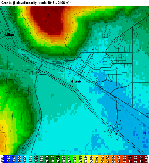
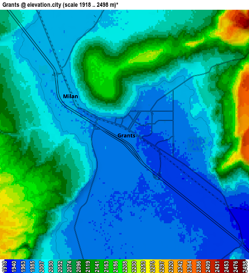
Below is the Elevation map of Grants, which displays elevation range with different colors. Scale of the first map is from 1918 to 2198 m (6293 to 7211 ft) with average elevation of 1999.3 meters (=6559 ft) [note 1]
These maps also provides idea of topography and contour of this city, they are displayed at different zoom levels. More info about maps, scale and edge coordinates you can find below images.
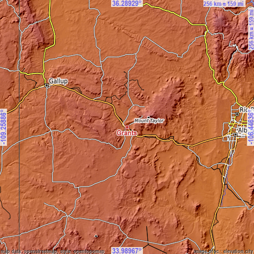
| \ | Map #1 | Map #2 | Topo.Map |
| Scale [m] | 1918..2198 m | 1918..2498 m | × |
| Scale [ft] | 6293..7211 ft | 6293..8196 ft | × |
| Average | 1999.3 m = 6559 ft | 2044.7 m = 6708 ft | × |
| Width | 7.99 km = 5 mi | 15.98 km = 9.9 mi | 255.7 km = 158.9 mi |
| Height | 7.99 km = 5 mi | 15.98 km = 9.9 mi | 255.7 km = 158.9 mi |
| ↑Max Latitude | 35.183525° | 35.219434° | 36.28929° |
| Latitude at center | 35.1476° | 35.1476° | 35.1476° |
| ↓Min Latitude | 35.111659° | 35.075703° | 33.98967° |
| ← Min Longitude | -107.896555° | -107.940501° | -109.25886° |
| Longitude center | -107.85261° | -107.85261° | -107.85261° |
| →Max Longitude | -107.808665° | -107.764719° | -106.44636° |
Nearby cities:
Cities around Grants sort by population:
• Gallup elevation 1985 m
91.1 km,  297°
297°
• Zuni Pueblo 1921 m
91.2 km,  264°
264°
• Paradise Hills 1619 m
104.8 km,  86°
86°
• Milan 1989 m
4.3 km,  305°
305°
• Crownpoint 2129 m
64.9 km,  335°
335°
• Thoreau 2184 m
44 km, 310°
• Black Rock 1972 m
85.6 km,  265°
265°
• Laguna 1767 m
44.5 km,  106°
106°
• Skyline-Ganipa 1901 m
25.2 km,  120°
120°
• Church Rock 2042 m
80.2 km, 302°
• Alamo 1885 m
86.6 km,  158°
158°
• Twin Lakes 1941 m
104.3 km, 306°
Multilingual:
 En español:
Grants elevación 1970 m.
 En France:
Grants élévation 1970 m.


Sources and notes:
- [note 1] Map square and city borders are not equal. Map elevation data is calculated only from area inside that square.
- [src 1] Elevation data from geonames database provided with same terms of usage.
- [src 2] The elevation map of Grants is generated using elevation data from NASA's 3 arcsec (90m) resolution SRTM data.
- [src 3] Base (background) map © OpenStreetMap contributors tiles are generated by Geofabrik and OpenTopoMap.
Copyright & License:
This Grants Elevation Map is licensed under CC BY-SA. You may reuse any part from this page, if you give a proper credit by linking to this URL:
 More info on terms of use page.