Columbus elevation
Columbus (New Mexico, Luna County), United States elevation is 1239 meters and Columbus elevation in feet is 4065 ft above sea level [src 1]. Columbus is a populated place (feature code) with elevation that is 960 meters (3150 ft) bigger than average city elevation in United States.
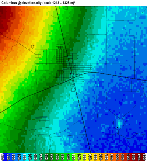
Below is the Elevation map of Columbus, which displays elevation range with different colors. Scale of the first map is from 1213 to 1328 m (3980 to 4357 ft) with average elevation of 1245.5 meters (=4086 ft) [note 1]
These maps also provides idea of topography and contour of this city, they are displayed at different zoom levels. More info about maps, scale and edge coordinates you can find below images.
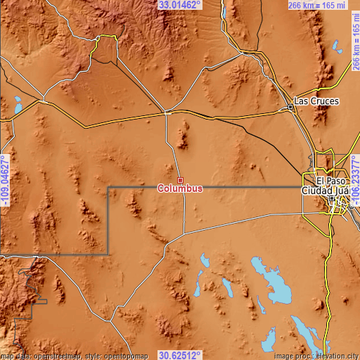
| \ | Map #1 | Topo.Map |
| Scale [m] | 1213..1328 m | × |
| Scale [ft] | 3980..4357 ft | × |
| Average | 1245.5 m = 4086 ft | × |
| Width | 8.3 km = 5.2 mi | 265.7 km = 165.1 mi |
| Height | 8.3 km = 5.2 mi | 265.7 km = 165.1 mi |
| ↑Max Latitude | 31.86493° | 33.01462° |
| Latitude at center | 31.8276° | 31.8276° |
| ↓Min Latitude | 31.790255° | 30.62512° |
| ← Min Longitude | -107.683965° | -109.04627° |
| Longitude center | -107.64002° | -107.64002° |
| →Max Longitude | -107.596075° | -106.23377° |
Nearby cities:
Cities around Columbus sort by population:
• Las Cruces elevation 1189 m
97.4 km,  56°
56°
• Deming 1326 m
50.3 km,  347°
347°
• Canutillo 1144 m
98.6 km,  84°
84°
• Santa Teresa 1152 m
94.6 km,  88°
88°
• University Park 1193 m
97.7 km, 58°
• Vado 1161 m
97.5 km,  71°
71°
• San Ysidro 1190 m
97.4 km,  53°
53°
• Mesilla 1178 m
93.1 km, 58°
• Keeler Farm 1341 m
55.5 km, 348°
• San Miguel 1168 m
92.8 km, 66°
• Mesquite 1169 m
96.5 km, 67°
• La Union 1153 m
93.4 km, 81°
Multilingual:
 En español:
Columbus elevación 1239 m.
 En France:
Columbus élévation 1239 m.
 Auf Deutsch:
Columbus höhe über dem Meeresspiegel ist 1239 m.

Sources and notes:
- [note 1] Map square and city borders are not equal. Map elevation data is calculated only from area inside that square.
- [src 1] Elevation data from geonames database provided with same terms of usage.
- [src 2] The elevation map of Columbus is generated using elevation data from NASA's 3 arcsec (90m) resolution SRTM data.
- [src 3] Base (background) map © OpenStreetMap contributors tiles are generated by Geofabrik and OpenTopoMap.
Copyright & License:
This Columbus Elevation Map is licensed under CC BY-SA. You may reuse any part from this page, if you give a proper credit by linking to this URL:
 More info on terms of use page.