Yucca Valley elevation
Yucca Valley (California, San Bernardino County), United States elevation is 1027 meters and Yucca Valley elevation in feet is 3369 ft above sea level [src 1]. Yucca Valley is a populated place (feature code) with elevation that is 748 meters (2454 ft) bigger than average city elevation in United States.
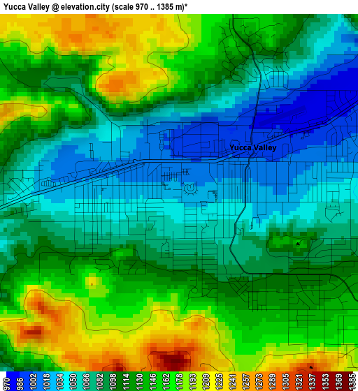
Below is the Elevation map of Yucca Valley, which displays elevation range with different colors. Scale of the first map is from 970 to 1385 m (3182 to 4544 ft) with average elevation of 1109.8 meters (=3641 ft) [note 1]
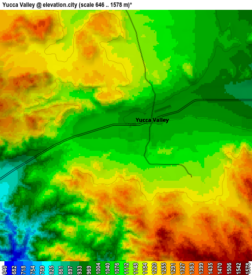
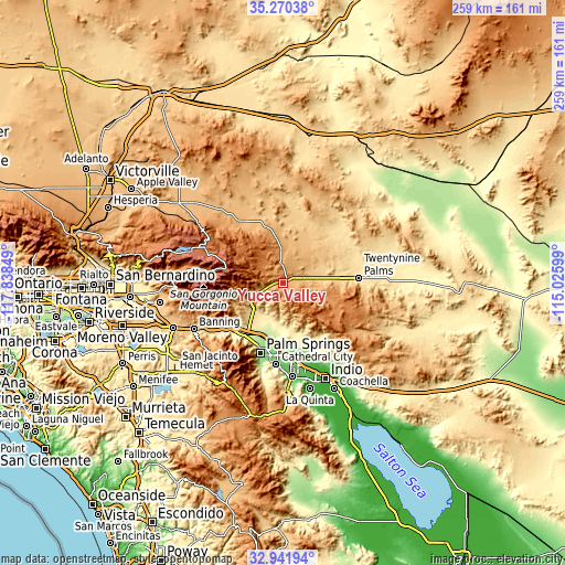
These maps also provides idea of topography and contour of this city, they are displayed at different zoom levels. More info about maps, scale and edge coordinates you can find below images.
| \ | Map #1 | Map #2 | Topo.Map |
| Scale [m] | 970..1385 m | 646..1578 m | × |
| Scale [ft] | 3182..4544 ft | 2119..5177 ft | × |
| Average | 1109.8 m = 3641 ft | 1135.6 m = 3726 ft | × |
| Width | 8.09 km = 5 mi | 16.18 km = 10.1 mi | 258.9 km = 160.9 mi |
| Height | 8.09 km = 5 mi | 16.18 km = 10.1 mi | 258.9 km = 160.9 mi |
| ↑Max Latitude | 34.150545° | 34.186905° | 35.27038° |
| Latitude at center | 34.11417° | 34.11417° | 34.11417° |
| ↓Min Latitude | 34.077779° | 34.041372° | 32.94194° |
| ← Min Longitude | -116.476185° | -116.520131° | -117.83849° |
| Longitude center | -116.43224° | -116.43224° | -116.43224° |
| →Max Longitude | -116.388295° | -116.344349° | -115.02599° |
Nearby cities:
Cities around Yucca Valley sort by population:
• Cathedral City elevation 100 m
37.3 km,  184°
184°
• Palm Springs 148 m
33.2 km,  198°
198°
• Desert Hot Springs 329 m
18.2 km, 201°
• Twentynine Palms 607 m
34.9 km,  86°
86°
• Big Bear City 2071 m
41.3 km,  293°
293°
• Thousand Palms 75 m
32.9 km,  173°
173°
• Garnet 217 m
25.8 km, 203°
• Joshua Tree 836 m
11.2 km,  78°
78°
• Desert Edge 298 m
21.1 km, 182°
• Morongo Valley 785 m
15.6 km,  241°
241°
• Cabazon 559 m
39.4 km, 236°
• Sky Valley 321 m
26 km,  163°
163°
Multilingual:
 En español:
Yucca Valley elevación 1027 m.
 En France:
Yucca Valley élévation 1027 m.
 Auf Deutsch:
Yucca Valley höhe über dem Meeresspiegel ist 1027 m.

Sources and notes:
- [note 1] Map square and city borders are not equal. Map elevation data is calculated only from area inside that square.
- [src 1] Elevation data from geonames database provided with same terms of usage.
- [src 2] The elevation map of Yucca Valley is generated using elevation data from NASA's 3 arcsec (90m) resolution SRTM data.
- [src 3] Base (background) map © OpenStreetMap contributors tiles are generated by Geofabrik and OpenTopoMap.
Copyright & License:
This Yucca Valley Elevation Map is licensed under CC BY-SA. You may reuse any part from this page, if you give a proper credit by linking to this URL:
 More info on terms of use page.