Cabazon elevation
Cabazon (California, Riverside County), United States elevation is 559 meters and Cabazon elevation in feet is 1834 ft above sea level [src 1]. Cabazon is a populated place (feature code) with elevation that is 280 meters (919 ft) bigger than average city elevation in United States.
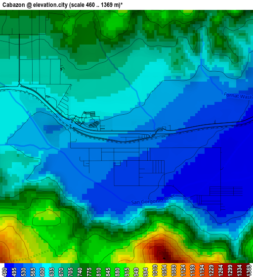
Below is the Elevation map of Cabazon, which displays elevation range with different colors. Scale of the first map is from 460 to 1369 m (1509 to 4491 ft) with average elevation of 664.1 meters (=2179 ft) [note 1]
These maps also provides idea of topography and contour of this city, they are displayed at different zoom levels. More info about maps, scale and edge coordinates you can find below images.
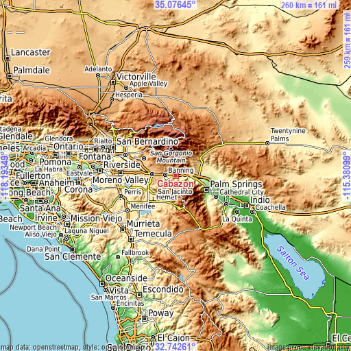
| \ | Map #1 | Topo.Map |
| Scale [m] | 460..1369 m | × |
| Scale [ft] | 1509..4491 ft | × |
| Average | 664.1 m = 2179 ft | × |
| Width | 8.11 km = 5 mi | 259.5 km = 161.2 mi |
| Height | 8.11 km = 5 mi | 259.5 km = 161.2 mi |
| ↑Max Latitude | 33.95398° | 35.07645° |
| Latitude at center | 33.91752° | 33.91752° |
| ↓Min Latitude | 33.881045° | 32.74261° |
| ← Min Longitude | -116.831185° | -118.19349° |
| Longitude center | -116.78724° | -116.78724° |
| →Max Longitude | -116.743295° | -115.38099° |
Nearby cities:
Cities around Cabazon sort by population:
• Hemet elevation 487 m
25.5 km,  222°
222°
• Palm Springs 148 m
24.4 km,  113°
113°
• San Jacinto 480 m
21.7 km,  226°
226°
• Beaumont 797 m
17.6 km,  274°
274°
• Banning 715 m
8.3 km,  276°
276°
• East Hemet 518 m
24.2 km, 215°
• Valle Vista 541 m
21.3 km,  207°
207°
• Garnet 217 m
22.4 km,  94°
94°
• Cherry Valley 862 m
18.6 km,  289°
289°
• Idyllwild-Pine Cove 1661 m
20.1 km,  163°
163°
• Idyllwild 1613 m
20.7 km, 162°
• Morongo Valley 785 m
23.9 km,  52°
52°
Multilingual:
 En español:
Cabazon elevación 559 m.
 En France:
Cabazon élévation 559 m.


Sources and notes:
- [note 1] Map square and city borders are not equal. Map elevation data is calculated only from area inside that square.
- [src 1] Elevation data from geonames database provided with same terms of usage.
- [src 2] The elevation map of Cabazon is generated using elevation data from NASA's 3 arcsec (90m) resolution SRTM data.
- [src 3] Base (background) map © OpenStreetMap contributors tiles are generated by Geofabrik and OpenTopoMap.
Copyright & License:
This Cabazon Elevation Map is licensed under CC BY-SA. You may reuse any part from this page, if you give a proper credit by linking to this URL:
 More info on terms of use page.