Val Verde elevation
Val Verde (California, Los Angeles County), United States elevation is 364 meters and Val Verde elevation in feet is 1194 ft above sea level [src 1]. Val Verde is a populated place (feature code) with elevation that is 85 meters (279 ft) bigger than average city elevation in United States.
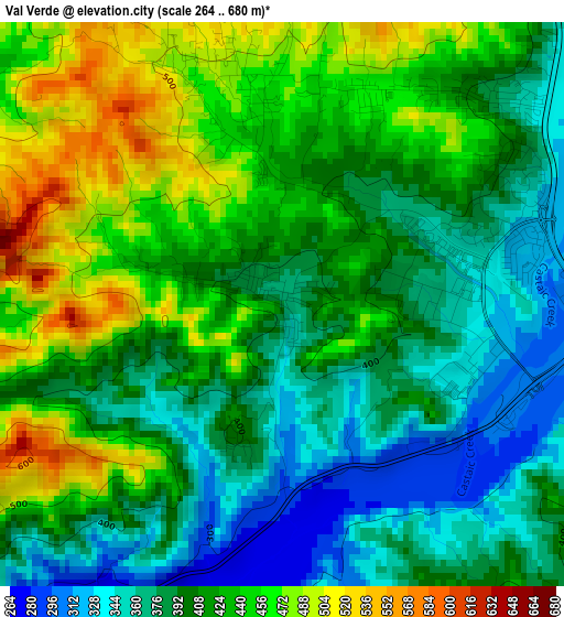
Below is the Elevation map of Val Verde, which displays elevation range with different colors. Scale of the first map is from 264 to 680 m (866 to 2231 ft) with average elevation of 412.6 meters (=1354 ft) [note 1]
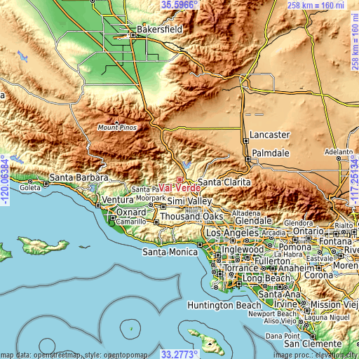
These maps also provides idea of topography and contour of this city, they are displayed at different zoom levels. More info about maps, scale and edge coordinates you can find below images.
| \ | Map #1 | Topo.Map |
| Scale [m] | 264..680 m | × |
| Scale [ft] | 866..2231 ft | × |
| Average | 412.6 m = 1354 ft | × |
| Width | 8.06 km = 5 mi | 257.9 km = 160.3 mi |
| Height | 8.06 km = 5 mi | 257.9 km = 160.3 mi |
| ↑Max Latitude | 34.481232° | 35.5966° |
| Latitude at center | 34.445° | 34.445° |
| ↓Min Latitude | 34.408752° | 33.2773° |
| ← Min Longitude | -118.701535° | -120.06384° |
| Longitude center | -118.65759° | -118.65759° |
| →Max Longitude | -118.613645° | -117.25134° |
Nearby cities:
Cities around Val Verde sort by population:
• Santa Clarita elevation 368 m
12.1 km,  119°
119°
• Valencia 312 m
4.4 km,  92°
92°
• Simi Valley 236 m
22.6 km,  210°
210°
• Northridge 248 m
26.5 km,  155°
155°
• Chatsworth 301 m
21.5 km,  166°
166°
• Moorpark 160 m
27.2 km,  229°
229°
• San Fernando 327 m
27 km,  132°
132°
• Castaic 374 m
5.8 km,  33°
33°
• Stevenson Ranch 428 m
9.8 km, 128°
• Fillmore 143 m
24.4 km,  257°
257°
• Piru 218 m
12.9 km, 255°
• Santa Susana 297 m
19.8 km,  193°
193°
Multilingual:
 En español:
Val Verde elevación 364 m.
 En France:
Val Verde élévation 364 m.
 Auf Deutsch:
Val Verde höhe über dem Meeresspiegel ist 364 m.

Sources and notes:
- [note 1] Map square and city borders are not equal. Map elevation data is calculated only from area inside that square.
- [src 1] Elevation data from geonames database provided with same terms of usage.
- [src 2] The elevation map of Val Verde is generated using elevation data from NASA's 3 arcsec (90m) resolution SRTM data.
- [src 3] Base (background) map © OpenStreetMap contributors tiles are generated by Geofabrik and OpenTopoMap.
Copyright & License:
This Val Verde Elevation Map is licensed under CC BY-SA. You may reuse any part from this page, if you give a proper credit by linking to this URL:
 More info on terms of use page.