Talmage elevation
Talmage (California, Mendocino County), United States elevation is 189 meters and Talmage elevation in feet is 620 ft above sea level [src 1]. Talmage is a populated place (feature code) with elevation that is 90 meters (295 ft) smaller than average city elevation in United States.
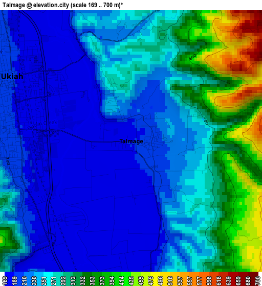
Below is the Elevation map of Talmage, which displays elevation range with different colors. Scale of the first map is from 169 to 700 m (554 to 2297 ft) with average elevation of 261.6 meters (=858 ft) [note 1]
These maps also provides idea of topography and contour of this city, they are displayed at different zoom levels. More info about maps, scale and edge coordinates you can find below images.
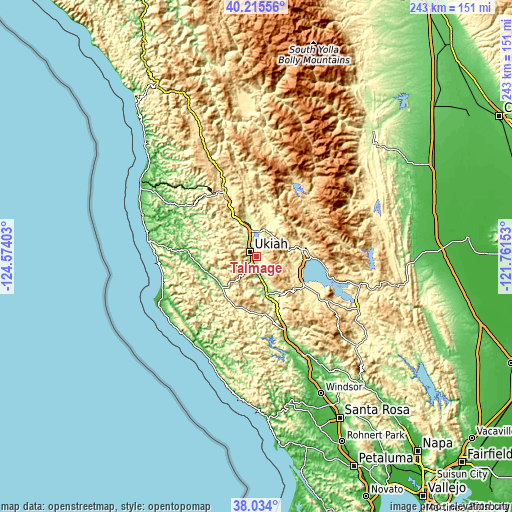
| \ | Map #1 | Topo.Map |
| Scale [m] | 169..700 m | × |
| Scale [ft] | 554..2297 ft | × |
| Average | 261.6 m = 858 ft | × |
| Width | 7.58 km = 4.7 mi | 242.6 km = 150.7 mi |
| Height | 7.58 km = 4.7 mi | 242.6 km = 150.7 mi |
| ↑Max Latitude | 39.167309° | 40.21556° |
| Latitude at center | 39.13323° | 39.13323° |
| ↓Min Latitude | 39.099134° | 38.034° |
| ← Min Longitude | -123.211725° | -124.57403° |
| Longitude center | -123.16778° | -123.16778° |
| →Max Longitude | -123.123835° | -121.76153° |
Nearby cities:
Cities around Talmage sort by population:
• Ukiah elevation 194 m
3.9 km,  298°
298°
• Cloverdale 103 m
38.7 km,  160°
160°
• Willits 422 m
34.7 km,  332°
332°
• Lakeport 414 m
23.9 km,  114°
114°
• Kelseyville 422 m
33.2 km,  121°
121°
• North Lakeport 421 m
23.2 km,  102°
102°
• Lucerne 405 m
32.4 km, 98°
• Nice 414 m
27.6 km,  92°
92°
• Redwood Valley 221 m
15 km,  347°
347°
• Upper Lake 410 m
22.5 km,  81°
81°
• Boonville 121 m
22 km,  231°
231°
• Soda Bay 432 m
35.8 km, 114°
Multilingual:
 En español:
Talmage elevación 189 m.
 En France:
Talmage élévation 189 m.


Sources and notes:
- [note 1] Map square and city borders are not equal. Map elevation data is calculated only from area inside that square.
- [src 1] Elevation data from geonames database provided with same terms of usage.
- [src 2] The elevation map of Talmage is generated using elevation data from NASA's 3 arcsec (90m) resolution SRTM data.
- [src 3] Base (background) map © OpenStreetMap contributors tiles are generated by Geofabrik and OpenTopoMap.
Copyright & License:
This Talmage Elevation Map is licensed under CC BY-SA. You may reuse any part from this page, if you give a proper credit by linking to this URL:
 More info on terms of use page.