Soda Bay elevation
Soda Bay (California, Lake County), United States elevation is 432 meters and Soda Bay elevation in feet is 1417 ft above sea level [src 1]. Soda Bay is a populated place (feature code) with elevation that is 153 meters (502 ft) bigger than average city elevation in United States.
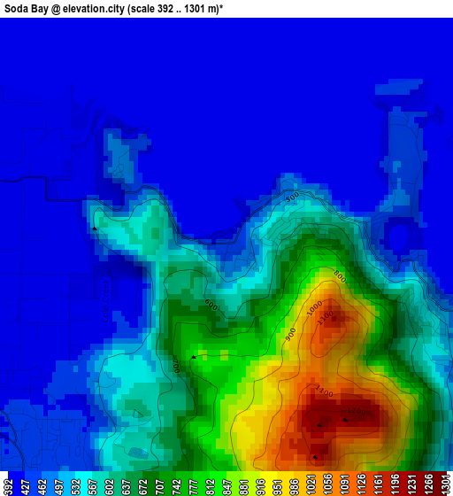
Below is the Elevation map of Soda Bay, which displays elevation range with different colors. Scale of the first map is from 392 to 1301 m (1286 to 4268 ft) with average elevation of 551.5 meters (=1809 ft) [note 1]
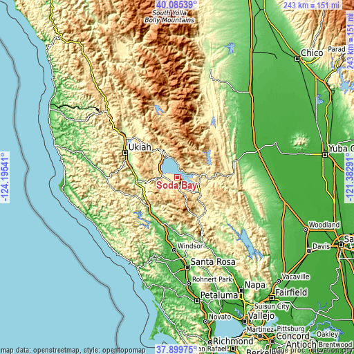
These maps also provides idea of topography and contour of this city, they are displayed at different zoom levels. More info about maps, scale and edge coordinates you can find below images.
| \ | Map #1 | Topo.Map |
| Scale [m] | 392..1301 m | × |
| Scale [ft] | 1286..4268 ft | × |
| Average | 551.5 m = 1809 ft | × |
| Width | 7.59 km = 4.7 mi | 243 km = 151 mi |
| Height | 7.59 km = 4.7 mi | 243 km = 151 mi |
| ↑Max Latitude | 39.035153° | 40.08539° |
| Latitude at center | 39.00101° | 39.00101° |
| ↓Min Latitude | 38.96685° | 37.89975° |
| ← Min Longitude | -122.833105° | -124.19541° |
| Longitude center | -122.78916° | -122.78916° |
| →Max Longitude | -122.745215° | -121.38291° |
Nearby cities:
Cities around Soda Bay sort by population:
• Clearlake elevation 434 m
14.9 km,  108°
108°
• Hidden Valley Lake 354 m
29.3 km,  137°
137°
• Lakeport 414 m
11.9 km,  293°
293°
• Kelseyville 422 m
5 km,  239°
239°
• North Lakeport 421 m
14 km,  314°
314°
• Clear Lake Riviera 535 m
7.9 km,  131°
131°
• Lucerne 405 m
9.9 km,  356°
356°
• Nice 414 m
14.5 km,  339°
339°
• Clearlake Oaks 413 m
10.5 km,  74°
74°
• Cobb 835 m
20.7 km,  163°
163°
• Lower Lake 419 m
18.5 km,  123°
123°
• Upper Lake 410 m
21 km,  330°
330°
Multilingual:
 En español:
Soda Bay elevación 432 m.
 En France:
Soda Bay élévation 432 m.
 Auf Deutsch:
Soda Bay höhe über dem Meeresspiegel ist 432 m.

Sources and notes:
- [note 1] Map square and city borders are not equal. Map elevation data is calculated only from area inside that square.
- [src 1] Elevation data from geonames database provided with same terms of usage.
- [src 2] The elevation map of Soda Bay is generated using elevation data from NASA's 3 arcsec (90m) resolution SRTM data.
- [src 3] Base (background) map © OpenStreetMap contributors tiles are generated by Geofabrik and OpenTopoMap.
Copyright & License:
This Soda Bay Elevation Map is licensed under CC BY-SA. You may reuse any part from this page, if you give a proper credit by linking to this URL:
 More info on terms of use page.