Taft elevation
Taft (California, Kern County), United States elevation is 292 meters and Taft elevation in feet is 958 ft above sea level [src 1]. Taft is a populated place (feature code) with elevation that is 13 meters (43 ft) bigger than average city elevation in United States.
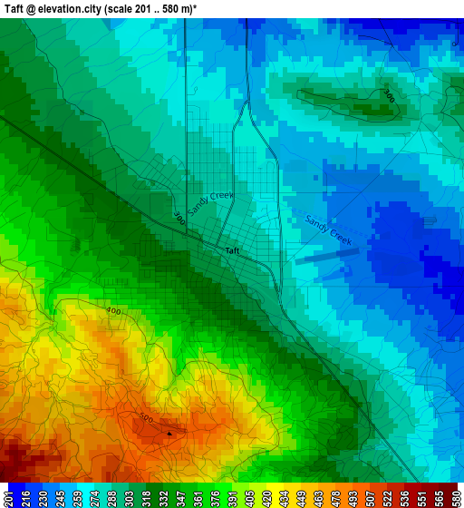
Below is the Elevation map of Taft, which displays elevation range with different colors. Scale of the first map is from 201 to 580 m (659 to 1903 ft) with average elevation of 321.7 meters (=1055 ft) [note 1]
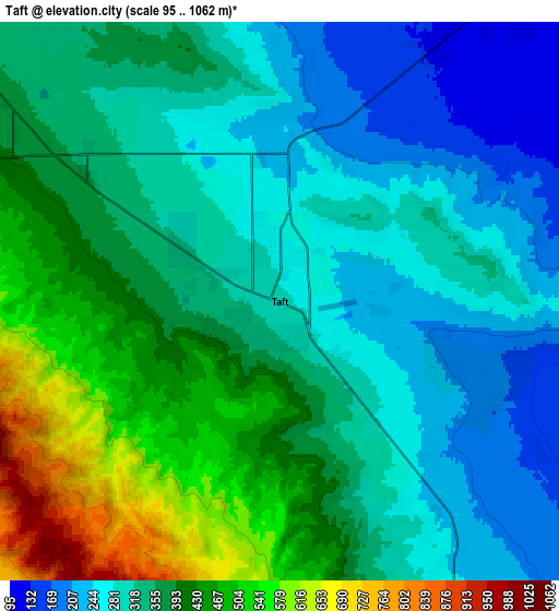
These maps also provides idea of topography and contour of this city, they are displayed at different zoom levels. More info about maps, scale and edge coordinates you can find below images.
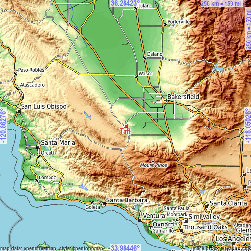
| \ | Map #1 | Map #2 | Topo.Map |
| Scale [m] | 201..580 m | 95..1062 m | × |
| Scale [ft] | 659..1903 ft | 312..3484 ft | × |
| Average | 321.7 m = 1055 ft | 356 m = 1168 ft | × |
| Width | 7.99 km = 5 mi | 15.98 km = 9.9 mi | 255.7 km = 158.9 mi |
| Height | 7.99 km = 5 mi | 15.98 km = 9.9 mi | 255.7 km = 158.9 mi |
| ↑Max Latitude | 35.178397° | 35.214308° | 36.28423° |
| Latitude at center | 35.14247° | 35.14247° | 35.14247° |
| ↓Min Latitude | 35.106527° | 35.070568° | 33.98446° |
| ← Min Longitude | -119.500455° | -119.544401° | -120.86276° |
| Longitude center | -119.45651° | -119.45651° | -119.45651° |
| →Max Longitude | -119.412565° | -119.368619° | -118.05026° |
Nearby cities:
Cities around Taft sort by population:
• Bakersfield elevation 130 m
47.3 km,  57°
57°
• Oildale 147 m
50.2 km,  52°
52°
• Shafter 107 m
43.2 km,  22°
22°
• Rosedale 116 m
38.9 km, 46°
• Greenacres 120 m
41.3 km, 49°
• Ford City 272 m
1.3 km,  1°
1°
• Greenfield 109 m
43.5 km,  71°
71°
• Pine Mountain Club 1714 m
43.2 km,  139°
139°
• South Taft 310 m
0.9 km,  178°
178°
• Taft Heights 357 m
1.7 km,  239°
239°
• Buttonwillow 86 m
28.7 km,  357°
357°
• Maricopa 267 m
10.6 km,  151°
151°
Multilingual:
 En español:
Taft elevación 292 m.
 En France:
Taft élévation 292 m.


Sources and notes:
- [note 1] Map square and city borders are not equal. Map elevation data is calculated only from area inside that square.
- [src 1] Elevation data from geonames database provided with same terms of usage.
- [src 2] The elevation map of Taft is generated using elevation data from NASA's 3 arcsec (90m) resolution SRTM data.
- [src 3] Base (background) map © OpenStreetMap contributors tiles are generated by Geofabrik and OpenTopoMap.
Copyright & License:
This Taft Elevation Map is licensed under CC BY-SA. You may reuse any part from this page, if you give a proper credit by linking to this URL:
 More info on terms of use page.