Sutter Creek elevation
Sutter Creek (California, Amador County), United States elevation is 365 meters and Sutter Creek elevation in feet is 1198 ft above sea level [src 1]. Sutter Creek is a populated place (feature code) with elevation that is 86 meters (282 ft) bigger than average city elevation in United States.
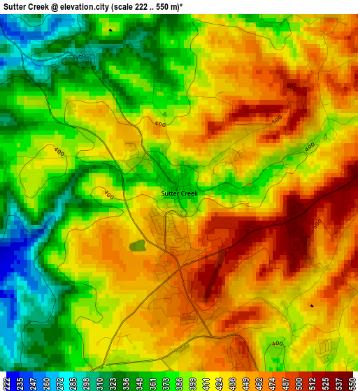
Below is the Elevation map of Sutter Creek, which displays elevation range with different colors. Scale of the first map is from 222 to 550 m (728 to 1804 ft) with average elevation of 411.3 meters (=1349 ft) [note 1]
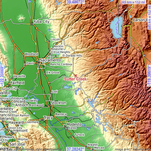
These maps also provides idea of topography and contour of this city, they are displayed at different zoom levels. More info about maps, scale and edge coordinates you can find below images.
| \ | Map #1 | Topo.Map |
| Scale [m] | 222..550 m | × |
| Scale [ft] | 728..1804 ft | × |
| Average | 411.3 m = 1349 ft | × |
| Width | 7.66 km = 4.8 mi | 245.1 km = 152.3 mi |
| Height | 7.66 km = 4.8 mi | 245.1 km = 152.3 mi |
| ↑Max Latitude | 38.427405° | 39.48672° |
| Latitude at center | 38.39297° | 38.39297° |
| ↓Min Latitude | 38.358519° | 37.28242° |
| ← Min Longitude | -120.846385° | -122.20869° |
| Longitude center | -120.80244° | -120.80244° |
| →Max Longitude | -120.758495° | -119.39619° |
Nearby cities:
Cities around Sutter Creek sort by population:
• Ione elevation 96 m
12.2 km,  248°
248°
• Rancho Murieta 52 m
28.2 km,  295°
295°
• Jackson 370 m
5.5 km,  153°
153°
• Rancho Calaveras 168 m
29.9 km,  189°
189°
• Valley Springs 208 m
22.5 km, 185°
• San Andreas 310 m
24.3 km, 154°
• Buckhorn 1010 m
24.8 km,  74°
74°
• Pine Grove 763 m
12.7 km,  79°
79°
• Mountain Ranch 650 m
29.3 km,  128°
128°
• Red Corral 842 m
17.3 km, 83°
• Clay 32 m
31.8 km,  258°
258°
• Pioneer 920 m
20.5 km, 77°
Multilingual:
 En español:
Sutter Creek elevación 365 m.
 En France:
Sutter Creek élévation 365 m.
 Auf Deutsch:
Sutter Creek höhe über dem Meeresspiegel ist 365 m.

Sources and notes:
- [note 1] Map square and city borders are not equal. Map elevation data is calculated only from area inside that square.
- [src 1] Elevation data from geonames database provided with same terms of usage.
- [src 2] The elevation map of Sutter Creek is generated using elevation data from NASA's 3 arcsec (90m) resolution SRTM data.
- [src 3] Base (background) map © OpenStreetMap contributors tiles are generated by Geofabrik and OpenTopoMap.
Copyright & License:
This Sutter Creek Elevation Map is licensed under CC BY-SA. You may reuse any part from this page, if you give a proper credit by linking to this URL:
 More info on terms of use page.