Rancho Murieta elevation
Rancho Murieta (California, Sacramento County), United States elevation is 52 meters and Rancho Murieta elevation in feet is 171 ft above sea level [src 1]. Rancho Murieta is a populated place (feature code) with elevation that is 227 meters (745 ft) smaller than average city elevation in United States.
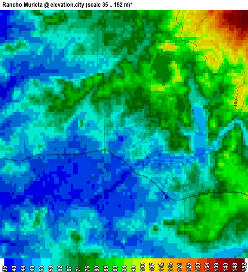
Below is the Elevation map of Rancho Murieta, which displays elevation range with different colors. Scale of the first map is from 35 to 152 m (115 to 499 ft) with average elevation of 63.3 meters (=208 ft) [note 1]
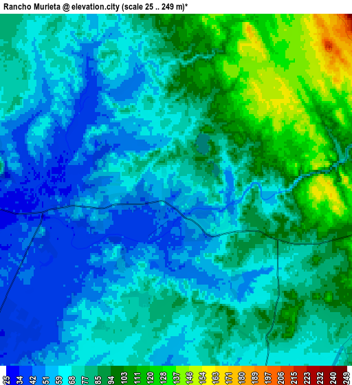
These maps also provides idea of topography and contour of this city, they are displayed at different zoom levels. More info about maps, scale and edge coordinates you can find below images.

| \ | Map #1 | Map #2 | Topo.Map |
| Scale [m] | 35..152 m | 25..249 m | × |
| Scale [ft] | 115..499 ft | 82..817 ft | × |
| Average | 63.3 m = 208 ft | 76.1 m = 250 ft | × |
| Width | 7.65 km = 4.8 mi | 15.3 km = 9.5 mi | 244.7 km = 152 mi |
| Height | 7.65 km = 4.8 mi | 15.3 km = 9.5 mi | 244.7 km = 152 mi |
| ↑Max Latitude | 38.536233° | 38.570599° | 39.59393° |
| Latitude at center | 38.50185° | 38.50185° | 38.50185° |
| ↓Min Latitude | 38.467451° | 38.433035° | 37.39295° |
| ← Min Longitude | -121.138615° | -121.182561° | -122.50092° |
| Longitude center | -121.09467° | -121.09467° | -121.09467° |
| →Max Longitude | -121.050725° | -121.006779° | -119.68842° |
Nearby cities:
Cities around Rancho Murieta sort by population:
• Folsom elevation 66 m
20.8 km,  340°
340°
• Rancho Cordova 28 m
20.5 km,  298°
298°
• El Dorado Hills 238 m
20.5 km,  3°
3°
• Orangevale 74 m
22.7 km,  329°
329°
• Fair Oaks 58 m
22.1 km,  315°
315°
• Vineyard 26 m
22.3 km,  259°
259°
• Cameron Park 372 m
20.8 km,  26°
26°
• Gold River 37 m
19.1 km, 316°
• Ione 96 m
21.8 km,  139°
139°
• Wilton 25 m
18.4 km,  237°
237°
• Shingle Springs 432 m
23.4 km,  38°
38°
• Clay 32 m
19.3 km,  197°
197°
Multilingual:
 En español:
Rancho Murieta elevación 52 m.
 En France:
Rancho Murieta élévation 52 m.
 Auf Deutsch:
Rancho Murieta höhe über dem Meeresspiegel ist 52 m.

Sources and notes:
- [note 1] Map square and city borders are not equal. Map elevation data is calculated only from area inside that square.
- [src 1] Elevation data from geonames database provided with same terms of usage.
- [src 2] The elevation map of Rancho Murieta is generated using elevation data from NASA's 3 arcsec (90m) resolution SRTM data.
- [src 3] Base (background) map © OpenStreetMap contributors tiles are generated by Geofabrik and OpenTopoMap.
Copyright & License:
This Rancho Murieta Elevation Map is licensed under CC BY-SA. You may reuse any part from this page, if you give a proper credit by linking to this URL:
 More info on terms of use page.