Selma elevation
Selma (California, Fresno County), United States elevation is 100 meters and Selma elevation in feet is 328 ft above sea level [src 1]. Selma is a populated place (feature code) with elevation that is 179 meters (587 ft) smaller than average city elevation in United States.
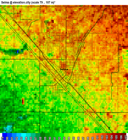
Below is the Elevation map of Selma, which displays elevation range with different colors. Scale of the first map is from 79 to 107 m (259 to 351 ft) with average elevation of 96.1 meters (=315 ft) [note 1]
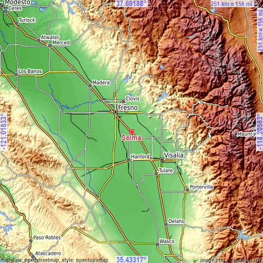
These maps also provides idea of topography and contour of this city, they are displayed at different zoom levels. More info about maps, scale and edge coordinates you can find below images.
| \ | Map #1 | Map #2 | Topo.Map |
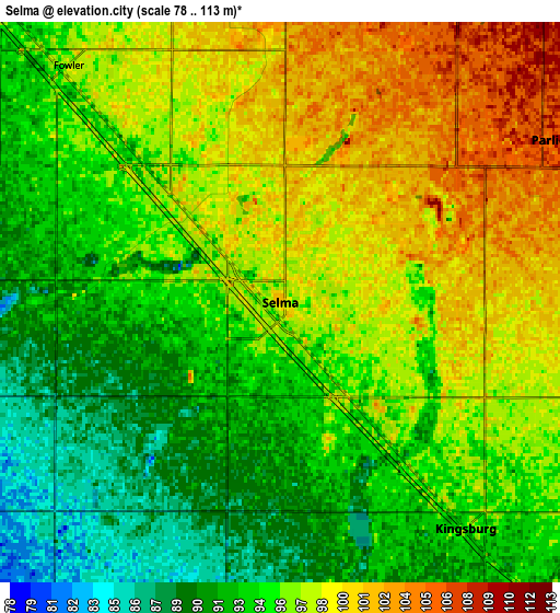
| Scale [m] | 79..107 m | 78..113 m | × |
| Scale [ft] | 259..351 ft | 256..371 ft | × |
| Average | 96.1 m = 315 ft | 95.5 m = 313 ft | × |
| Width | 7.85 km = 4.9 mi | 15.7 km = 9.8 mi | 251.1 km = 156 mi |
| Height | 7.85 km = 4.9 mi | 15.7 km = 9.8 mi | 251.1 km = 156 mi |
| ↑Max Latitude | 36.606065° | 36.641335° | 37.69188° |
| Latitude at center | 36.57078° | 36.57078° | 36.57078° |
| ↓Min Latitude | 36.535479° | 36.500161° | 35.43317° |
| ← Min Longitude | -119.656025° | -119.699971° | -121.01833° |
| Longitude center | -119.61208° | -119.61208° | -119.61208° |
| →Max Longitude | -119.568135° | -119.524189° | -118.20583° |
Nearby cities:
Cities around Selma sort by population:
• Reedley elevation 111 m
14.7 km,  78°
78°
• Sanger 115 m
16.1 km,  18°
18°
• Dinuba 105 m
20.3 km,  98°
98°
• Parlier 107 m
8.8 km,  59°
59°
• Kingsburg 95 m
8.2 km,  140°
140°
• Fowler 97 m
8.9 km,  318°
318°
• Sunnyside 101 m
21.3 km,  338°
338°
• Caruthers 78 m
20 km,  261°
261°
• Easton 89 m
18.2 km,  298°
298°
• London 93 m
18.4 km,  124°
124°
• Laton 80 m
16.7 km,  203°
203°
• Del Rey 105 m
10 km,  9°
9°
Multilingual:
 En español:
Selma elevación 100 m.
 En France:
Selma élévation 100 m.


Sources and notes:
- [note 1] Map square and city borders are not equal. Map elevation data is calculated only from area inside that square.
- [src 1] Elevation data from geonames database provided with same terms of usage.
- [src 2] The elevation map of Selma is generated using elevation data from NASA's 3 arcsec (90m) resolution SRTM data.
- [src 3] Base (background) map © OpenStreetMap contributors tiles are generated by Geofabrik and OpenTopoMap.
Copyright & License:
This Selma Elevation Map is licensed under CC BY-SA. You may reuse any part from this page, if you give a proper credit by linking to this URL:
 More info on terms of use page.