Dinuba elevation
Dinuba (California, Tulare County), United States elevation is 105 meters and Dinuba elevation in feet is 344 ft above sea level [src 1]. Dinuba is a populated place (feature code) with elevation that is 174 meters (571 ft) smaller than average city elevation in United States.
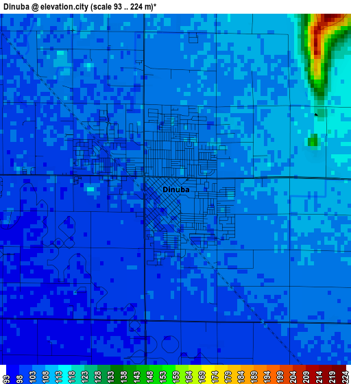
Below is the Elevation map of Dinuba, which displays elevation range with different colors. Scale of the first map is from 93 to 224 m (305 to 735 ft) with average elevation of 105.9 meters (=347 ft) [note 1]
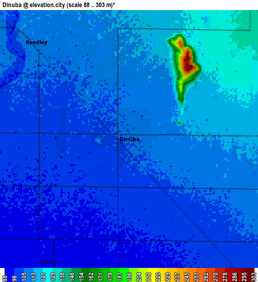
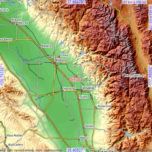
These maps also provides idea of topography and contour of this city, they are displayed at different zoom levels. More info about maps, scale and edge coordinates you can find below images.
| \ | Map #1 | Map #2 | Topo.Map |
| Scale [m] | 93..224 m | 88..303 m | × |
| Scale [ft] | 305..735 ft | 289..994 ft | × |
| Average | 105.9 m = 347 ft | 107.4 m = 352 ft | × |
| Width | 7.85 km = 4.9 mi | 15.7 km = 9.8 mi | 251.2 km = 156.1 mi |
| Height | 7.85 km = 4.9 mi | 15.7 km = 9.8 mi | 251.2 km = 156.1 mi |
| ↑Max Latitude | 36.578578° | 36.61386° | 37.66478° |
| Latitude at center | 36.54328° | 36.54328° | 36.54328° |
| ↓Min Latitude | 36.507966° | 36.472636° | 35.40527° |
| ← Min Longitude | -119.431015° | -119.474961° | -120.79332° |
| Longitude center | -119.38707° | -119.38707° | -119.38707° |
| →Max Longitude | -119.343125° | -119.299179° | -117.98082° |
Nearby cities:
Cities around Dinuba sort by population:
• Reedley elevation 111 m
8.2 km,  316°
316°
• Selma 100 m
20.3 km,  278°
278°
• Parlier 107 m
14.6 km,  301°
301°
• Kingsburg 95 m
15.3 km,  257°
257°
• Orange Cove 132 m
11.1 km,  35°
35°
• Orosi 119 m
8.9 km,  88°
88°
• Cutler 114 m
9.2 km,  103°
103°
• Goshen 90 m
21.6 km,  187°
187°
• London 93 m
9 km,  213°
213°
• Patterson Tract 102 m
20 km,  155°
155°
• Del Rey 105 m
22.5 km, 304°
• Minkler 127 m
21.1 km,  342°
342°
Multilingual:
 En español:
Dinuba elevación 105 m.
 En France:
Dinuba élévation 105 m.


Sources and notes:
- [note 1] Map square and city borders are not equal. Map elevation data is calculated only from area inside that square.
- [src 1] Elevation data from geonames database provided with same terms of usage.
- [src 2] The elevation map of Dinuba is generated using elevation data from NASA's 3 arcsec (90m) resolution SRTM data.
- [src 3] Base (background) map © OpenStreetMap contributors tiles are generated by Geofabrik and OpenTopoMap.
Copyright & License:
This Dinuba Elevation Map is licensed under CC BY-SA. You may reuse any part from this page, if you give a proper credit by linking to this URL:
 More info on terms of use page.