Rodeo elevation
Rodeo (California, Contra Costa County), United States elevation is 1 meters and Rodeo elevation in feet is 3 ft above sea level [src 1]. Rodeo is a populated place (feature code) with elevation that is 278 meters (912 ft) smaller than average city elevation in United States.
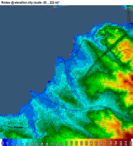
Below is the Elevation map of Rodeo, which displays elevation range with different colors. Scale of the first map is from -20 to 222 m (-66 to 728 ft) with average elevation of 54.3 meters (=178 ft) [note 1]
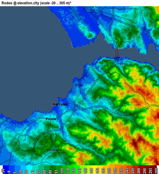
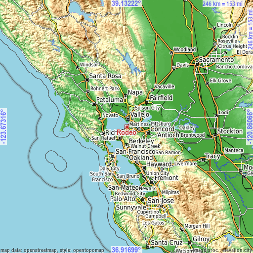
These maps also provides idea of topography and contour of this city, they are displayed at different zoom levels. More info about maps, scale and edge coordinates you can find below images.
| \ | Map #1 | Map #2 | Topo.Map |
| Scale [m] | -20..222 m | -20..305 m | × |
| Scale [ft] | -66..728 ft | -66..1001 ft | × |
| Average | 54.3 m = 178 ft | 81.1 m = 266 ft | × |
| Width | 7.7 km = 4.8 mi | 15.39 km = 9.6 mi | 246.3 km = 153 mi |
| Height | 7.7 km = 4.8 mi | 15.39 km = 9.6 mi | 246.3 km = 153 mi |
| ↑Max Latitude | 38.067586° | 38.102175° | 39.13222° |
| Latitude at center | 38.03298° | 38.03298° | 38.03298° |
| ↓Min Latitude | 37.998358° | 37.96372° | 36.91699° |
| ← Min Longitude | -122.310855° | -122.354801° | -123.67316° |
| Longitude center | -122.26691° | -122.26691° | -122.26691° |
| →Max Longitude | -122.222965° | -122.179019° | -120.86066° |
Nearby cities:
Cities around Rodeo sort by population:
• Vallejo elevation 22 m
8 km,  6°
6°
• San Pablo 13 m
10.5 km,  221°
221°
• Benicia 5 m
9.7 km,  79°
79°
• Hercules 22 m
2.6 km,  227°
227°
• Pinole 34 m
4.2 km, 221°
• El Sobrante 60 m
6.7 km,  201°
201°
• Tara Hills 32 m
6.2 km, 224°
• East Richmond Heights 111 m
10.6 km, 202°
• Crockett 39 m
5.2 km,  65°
65°
• Rollingwood 23 m
9.3 km, 216°
• Montalvin 19 m
7.1 km, 234°
• Bayview 12 m
5.4 km,  237°
237°
Multilingual:
 En español:
Rodeo elevación 1 m.
 En France:
Rodeo élévation 1 m.


Sources and notes:
- [note 1] Map square and city borders are not equal. Map elevation data is calculated only from area inside that square.
- [src 1] Elevation data from geonames database provided with same terms of usage.
- [src 2] The elevation map of Rodeo is generated using elevation data from NASA's 3 arcsec (90m) resolution SRTM data.
- [src 3] Base (background) map © OpenStreetMap contributors tiles are generated by Geofabrik and OpenTopoMap.
Copyright & License:
This Rodeo Elevation Map is licensed under CC BY-SA. You may reuse any part from this page, if you give a proper credit by linking to this URL:
 More info on terms of use page.