Ontario elevation
Ontario (California, San Bernardino County), United States elevation is 307 meters and Ontario elevation in feet is 1007 ft above sea level [src 1]. Ontario is a populated place (feature code) with elevation that is 28 meters (92 ft) bigger than average city elevation in United States.
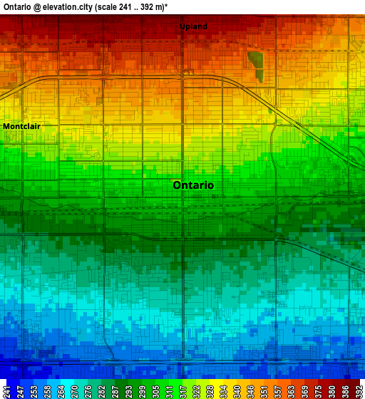
Below is the Elevation map of Ontario, which displays elevation range with different colors. Scale of the first map is from 241 to 392 m (791 to 1286 ft) with average elevation of 306.9 meters (=1007 ft) [note 1]
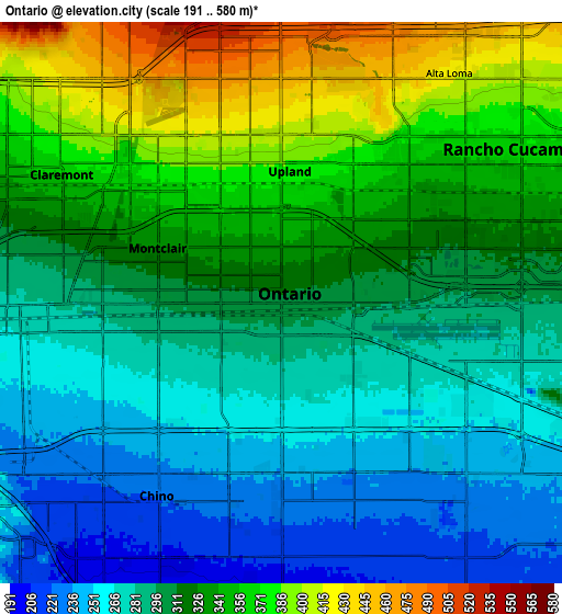
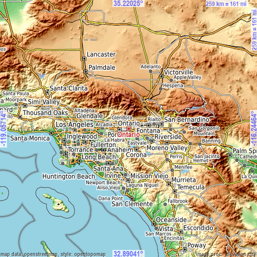
These maps also provides idea of topography and contour of this city, they are displayed at different zoom levels. More info about maps, scale and edge coordinates you can find below images.
| \ | Map #1 | Map #2 | Topo.Map |
| Scale [m] | 241..392 m | 191..580 m | × |
| Scale [ft] | 791..1286 ft | 627..1903 ft | × |
| Average | 306.9 m = 1007 ft | 312.6 m = 1026 ft | × |
| Width | 8.1 km = 5 mi | 16.19 km = 10.1 mi | 259.1 km = 161 mi |
| Height | 8.1 km = 5 mi | 16.19 km = 10.1 mi | 259.1 km = 161 mi |
| ↑Max Latitude | 34.099737° | 34.136119° | 35.22025° |
| Latitude at center | 34.06334° | 34.06334° | 34.06334° |
| ↓Min Latitude | 34.026927° | 33.990498° | 32.89041° |
| ← Min Longitude | -117.694835° | -117.738781° | -119.05714° |
| Longitude center | -117.65089° | -117.65089° | -117.65089° |
| →Max Longitude | -117.606945° | -117.562999° | -116.24464° |
Nearby cities:
Cities around Ontario sort by population:
• Rancho Cucamonga elevation 371 m
7.2 km,  48°
48°
• Pomona 264 m
9.4 km,  264°
264°
• Chino 222 m
6.7 km,  211°
211°
• Chino Hills 262 m
12.6 km,  232°
232°
• Upland 380 m
3.8 km,  3°
3°
• Eastvale 191 m
13.7 km,  144°
144°
• Montclair 328 m
3.9 km,  293°
293°
• Claremont 361 m
7.3 km,  300°
300°
• La Verne 328 m
11.5 km, 291°
• Jurupa Valley 224 m
14.7 km,  122°
122°
• Los Serranos 206 m
11.4 km, 207°
• San Antonio Heights 648 m
10.3 km,  357°
357°
Multilingual:
 En español:
Ontario elevación 307 m.
 En France:
Ontario élévation 307 m.


Sources and notes:
- [note 1] Map square and city borders are not equal. Map elevation data is calculated only from area inside that square.
- [src 1] Elevation data from geonames database provided with same terms of usage.
- [src 2] The elevation map of Ontario is generated using elevation data from NASA's 3 arcsec (90m) resolution SRTM data.
- [src 3] Base (background) map © OpenStreetMap contributors tiles are generated by Geofabrik and OpenTopoMap.
Copyright & License:
This Ontario Elevation Map is licensed under CC BY-SA. You may reuse any part from this page, if you give a proper credit by linking to this URL:
 More info on terms of use page.