Jurupa Valley elevation
Jurupa Valley (California, Riverside County), United States elevation is 224 meters and Jurupa Valley elevation in feet is 735 ft above sea level [src 1]. Jurupa Valley is a populated place (feature code) with elevation that is 55 meters (180 ft) smaller than average city elevation in United States.
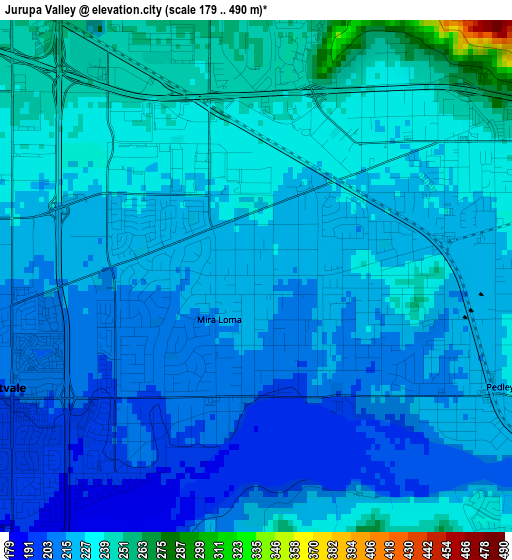
Below is the Elevation map of Jurupa Valley, which displays elevation range with different colors. Scale of the first map is from 179 to 490 m (587 to 1608 ft) with average elevation of 223.3 meters (=733 ft) [note 1]
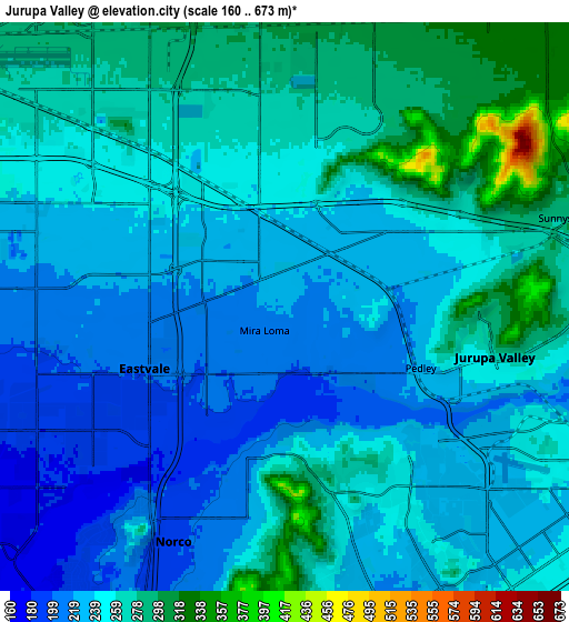
These maps also provides idea of topography and contour of this city, they are displayed at different zoom levels. More info about maps, scale and edge coordinates you can find below images.
| \ | Map #1 | Map #2 | Topo.Map |
| Scale [m] | 179..490 m | 160..673 m | × |
| Scale [ft] | 587..1608 ft | 525..2208 ft | × |
| Average | 223.3 m = 733 ft | 248.8 m = 816 ft | × |
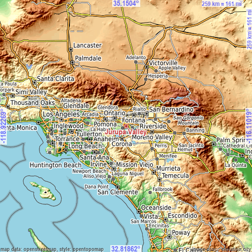
| Width | 8.1 km = 5 mi | 16.21 km = 10.1 mi | 259.3 km = 161.1 mi |
| Height | 8.1 km = 5 mi | 16.2 km = 10.1 mi | 259.3 km = 161.1 mi |
| ↑Max Latitude | 34.028938° | 34.06535° | 35.1504° |
| Latitude at center | 33.99251° | 33.99251° | 33.99251° |
| ↓Min Latitude | 33.956067° | 33.919608° | 32.81862° |
| ← Min Longitude | -117.560385° | -117.604331° | -118.92269° |
| Longitude center | -117.51644° | -117.51644° | -117.51644° |
| →Max Longitude | -117.472495° | -117.428549° | -116.11019° |
Nearby cities:
Cities around Jurupa Valley sort by population:
• Riverside elevation 257 m
11.9 km,  111°
111°
• Fontana 378 m
13.4 km,  34°
34°
• Rancho Cucamonga 371 m
14.5 km,  330°
330°
• Corona 213 m
13.8 km,  199°
199°
• Eastvale 191 m
5.5 km,  233°
233°
• Rubidoux 236 m
10.2 km,  87°
87°
• Norco 196 m
7.4 km, 203°
• Bloomington 338 m
14.1 km,  52°
52°
• Glen Avon 231 m
3.6 km, 53°
• Pedley 222 m
4.2 km,  117°
117°
• Home Gardens 207 m
12.7 km,  181°
181°
• Sunnyslope 279 m
8 km,  74°
74°
Multilingual:
 En español:
Jurupa Valley elevación 224 m.
 En France:
Jurupa Valley élévation 224 m.
 Auf Deutsch:
Jurupa Valley höhe über dem Meeresspiegel ist 224 m.

Sources and notes:
- [note 1] Map square and city borders are not equal. Map elevation data is calculated only from area inside that square.
- [src 1] Elevation data from geonames database provided with same terms of usage.
- [src 2] The elevation map of Jurupa Valley is generated using elevation data from NASA's 3 arcsec (90m) resolution SRTM data.
- [src 3] Base (background) map © OpenStreetMap contributors tiles are generated by Geofabrik and OpenTopoMap.
Copyright & License:
This Jurupa Valley Elevation Map is licensed under CC BY-SA. You may reuse any part from this page, if you give a proper credit by linking to this URL:
 More info on terms of use page.