Gilroy elevation
Gilroy (California, Santa Clara County), United States elevation is 60 meters and Gilroy elevation in feet is 197 ft above sea level [src 1]. Gilroy is a populated place (feature code) with elevation that is 219 meters (719 ft) smaller than average city elevation in United States.
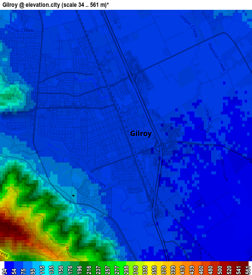
Below is the Elevation map of Gilroy, which displays elevation range with different colors. Scale of the first map is from 34 to 561 m (112 to 1841 ft) with average elevation of 89.8 meters (=295 ft) [note 1]
These maps also provides idea of topography and contour of this city, they are displayed at different zoom levels. More info about maps, scale and edge coordinates you can find below images.
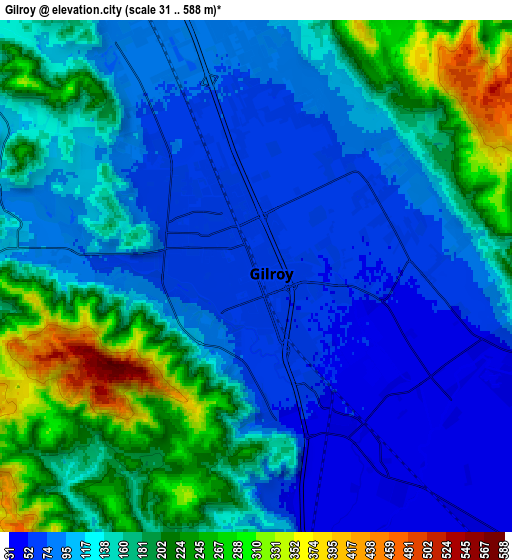
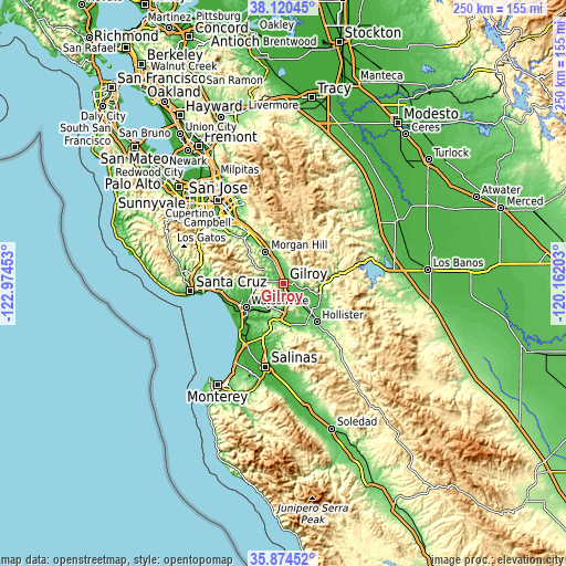
| \ | Map #1 | Map #2 | Topo.Map |
| Scale [m] | 34..561 m | 31..588 m | × |
| Scale [ft] | 112..1841 ft | 102..1929 ft | × |
| Average | 89.8 m = 295 ft | 141.8 m = 465 ft | × |
| Width | 7.8 km = 4.8 mi | 15.61 km = 9.7 mi | 249.7 km = 155.2 mi |
| Height | 7.8 km = 4.8 mi | 15.61 km = 9.7 mi | 249.7 km = 155.2 mi |
| ↑Max Latitude | 37.040866° | 37.075935° | 38.12045° |
| Latitude at center | 37.00578° | 37.00578° | 37.00578° |
| ↓Min Latitude | 36.970678° | 36.93556° | 35.87452° |
| ← Min Longitude | -121.612225° | -121.656171° | -122.97453° |
| Longitude center | -121.56828° | -121.56828° | -121.56828° |
| →Max Longitude | -121.524335° | -121.480389° | -120.16203° |
Nearby cities:
Cities around Gilroy sort by population:
• Watsonville elevation 10 m
19.8 km,  237°
237°
• Morgan Hill 107 m
15.8 km,  331°
331°
• Hollister 85 m
22.6 km,  139°
139°
• Interlaken 37 m
15.9 km,  247°
247°
• San Martin 87 m
9.6 km,  337°
337°
• Amesti 48 m
19.3 km,  255°
255°
• Freedom 37 m
19.8 km, 246°
• Pajaro 9 m
19.6 km,  234°
234°
• Las Lomas 12 m
21.5 km,  223°
223°
• Aromas 39 m
14.6 km,  206°
206°
• Corralitos 81 m
21.2 km, 264°
• San Juan Bautista 63 m
18 km,  171°
171°
Multilingual:
 En español:
Gilroy elevación 60 m.
 En France:
Gilroy élévation 60 m.


Sources and notes:
- [note 1] Map square and city borders are not equal. Map elevation data is calculated only from area inside that square.
- [src 1] Elevation data from geonames database provided with same terms of usage.
- [src 2] The elevation map of Gilroy is generated using elevation data from NASA's 3 arcsec (90m) resolution SRTM data.
- [src 3] Base (background) map © OpenStreetMap contributors tiles are generated by Geofabrik and OpenTopoMap.
Copyright & License:
This Gilroy Elevation Map is licensed under CC BY-SA. You may reuse any part from this page, if you give a proper credit by linking to this URL:
 More info on terms of use page.