Watsonville elevation
Watsonville (California, Santa Cruz County), United States elevation is 10 meters and Watsonville elevation in feet is 33 ft above sea level [src 1]. Watsonville is a populated place (feature code) with elevation that is 269 meters (883 ft) smaller than average city elevation in United States.
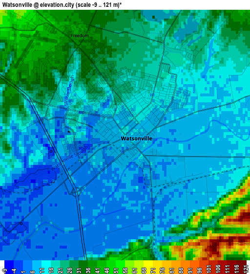
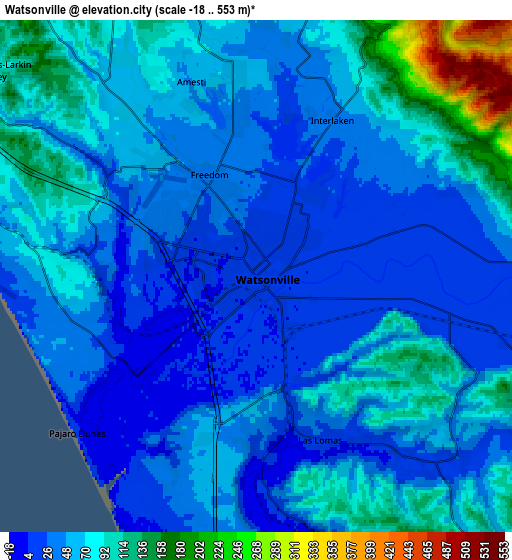
Below is the Elevation map of Watsonville, which displays elevation range with different colors. Scale of the first map is from -9 to 121 m (-30 to 397 ft) with average elevation of 18.4 meters (=60 ft) [note 1]
These maps also provides idea of topography and contour of this city, they are displayed at different zoom levels. More info about maps, scale and edge coordinates you can find below images.
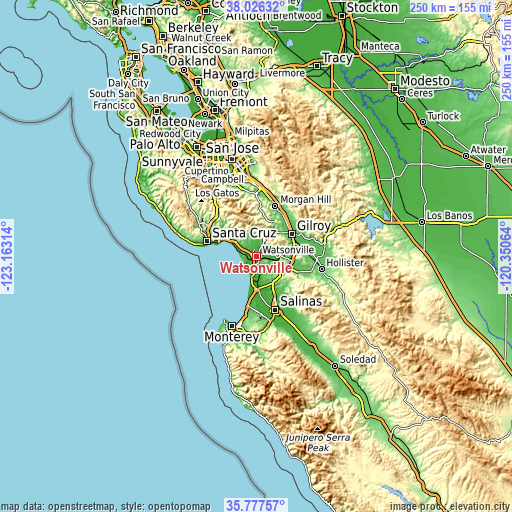
| \ | Map #1 | Map #2 | Topo.Map |
| Scale [m] | -9..121 m | -18..553 m | × |
| Scale [ft] | -30..397 ft | -59..1814 ft | × |
| Average | 18.4 m = 60 ft | 60.4 m = 198 ft | × |
| Width | 7.81 km = 4.9 mi | 15.63 km = 9.7 mi | 250 km = 155.3 mi |
| Height | 7.81 km = 4.9 mi | 15.63 km = 9.7 mi | 250 km = 155.3 mi |
| ↑Max Latitude | 36.94536° | 36.980473° | 38.02632° |
| Latitude at center | 36.91023° | 36.91023° | 36.91023° |
| ↓Min Latitude | 36.875084° | 36.839922° | 35.77757° |
| ← Min Longitude | -121.800835° | -121.844781° | -123.16314° |
| Longitude center | -121.75689° | -121.75689° | -121.75689° |
| →Max Longitude | -121.712945° | -121.668999° | -120.35064° |
Nearby cities:
Cities around Watsonville sort by population:
• Rio Del Mar elevation 49 m
14.3 km,  296°
296°
• Interlaken 37 m
5 km,  24°
24°
• Aptos 34 m
14.7 km, 300°
• Amesti 48 m
6.3 km,  341°
341°
• Freedom 37 m
3.1 km,  332°
332°
• Pajaro 9 m
1 km,  132°
132°
• Las Lomas 12 m
5.4 km,  158°
158°
• La Selva Beach 23 m
10 km,  287°
287°
• Aromas 39 m
10.4 km,  103°
103°
• Aptos Hills-Larkin Valley 83 m
8.9 km,  309°
309°
• Corralitos 81 m
9.8 km, 333°
• Elkhorn -1 m
9.7 km,  171°
171°
Multilingual:
 En español:
Watsonville elevación 10 m.
 En France:
Watsonville élévation 10 m.
 Auf Deutsch:
Watsonville höhe über dem Meeresspiegel ist 10 m.

Sources and notes:
- [note 1] Map square and city borders are not equal. Map elevation data is calculated only from area inside that square.
- [src 1] Elevation data from geonames database provided with same terms of usage.
- [src 2] The elevation map of Watsonville is generated using elevation data from NASA's 3 arcsec (90m) resolution SRTM data.
- [src 3] Base (background) map © OpenStreetMap contributors tiles are generated by Geofabrik and OpenTopoMap.
Copyright & License:
This Watsonville Elevation Map is licensed under CC BY-SA. You may reuse any part from this page, if you give a proper credit by linking to this URL:
 More info on terms of use page.