Fremont elevation
Fremont (California, Alameda County), United States elevation is 18 meters and Fremont elevation in feet is 59 ft above sea level [src 1]. Fremont is a populated place (feature code) with elevation that is 261 meters (856 ft) smaller than average city elevation in United States.
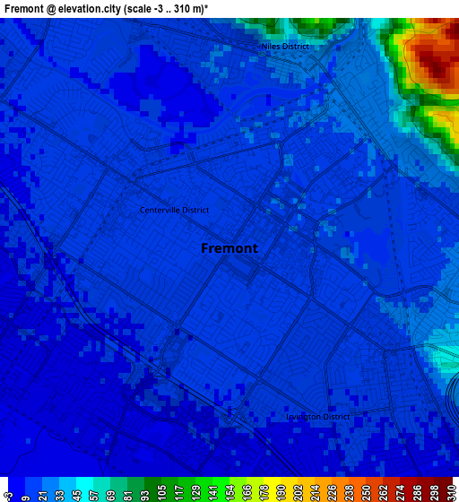
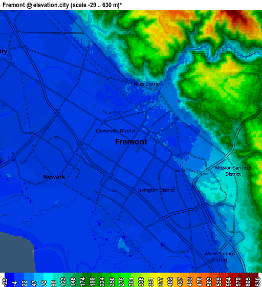
Below is the Elevation map of Fremont, which displays elevation range with different colors. Scale of the first map is from -3 to 310 m (-10 to 1017 ft) with average elevation of 21.5 meters (=71 ft) [note 1]
These maps also provides idea of topography and contour of this city, they are displayed at different zoom levels. More info about maps, scale and edge coordinates you can find below images.
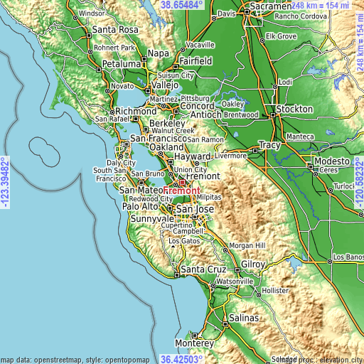
| \ | Map #1 | Map #2 | Topo.Map |
| Scale [m] | -3..310 m | -29..630 m | × |
| Scale [ft] | -10..1017 ft | -95..2067 ft | × |
| Average | 21.5 m = 71 ft | 71 m = 233 ft | × |
| Width | 7.75 km = 4.8 mi | 15.5 km = 9.6 mi | 247.9 km = 154 mi |
| Height | 7.75 km = 4.8 mi | 15.5 km = 9.6 mi | 247.9 km = 154 mi |
| ↑Max Latitude | 37.583103° | 37.617921° | 38.65484° |
| Latitude at center | 37.54827° | 37.54827° | 37.54827° |
| ↓Min Latitude | 37.51342° | 37.478554° | 36.42503° |
| ← Min Longitude | -122.032515° | -122.076461° | -123.39482° |
| Longitude center | -121.98857° | -121.98857° | -121.98857° |
| →Max Longitude | -121.944625° | -121.900679° | -120.58232° |
Nearby cities:
Cities around Fremont sort by population:
• Hayward elevation 32 m
15.7 km,  328°
328°
• Pleasanton 107 m
16.2 km,  38°
38°
• Milpitas 5 m
15.2 km,  151°
151°
• Union City 19 m
5.9 km, 332°
• Palo Alto 10 m
18 km,  229°
229°
• Castro Valley 49 m
18.4 km, 332°
• Dublin 108 m
17.7 km,  15°
15°
• Newark 5 m
5 km,  245°
245°
• East Palo Alto 3 m
16.1 km,  236°
236°
• San Lorenzo 10 m
19 km,  320°
320°
• Cherryland 18 m
17.7 km, 325°
• Fairview 174 m
15.3 km,  340°
340°
Multilingual:
 En español:
Fremont elevación 18 m.
 En France:
Fremont élévation 18 m.


Sources and notes:
- [note 1] Map square and city borders are not equal. Map elevation data is calculated only from area inside that square.
- [src 1] Elevation data from geonames database provided with same terms of usage.
- [src 2] The elevation map of Fremont is generated using elevation data from NASA's 3 arcsec (90m) resolution SRTM data.
- [src 3] Base (background) map © OpenStreetMap contributors tiles are generated by Geofabrik and OpenTopoMap.
Copyright & License:
This Fremont Elevation Map is licensed under CC BY-SA. You may reuse any part from this page, if you give a proper credit by linking to this URL:
 More info on terms of use page.