Frazier Park elevation
Frazier Park (California, Kern County), United States elevation is 1416 meters and Frazier Park elevation in feet is 4646 ft above sea level [src 1]. Frazier Park is a populated place (feature code) with elevation that is 1137 meters (3730 ft) bigger than average city elevation in United States.
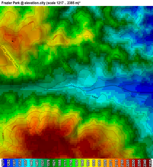
Below is the Elevation map of Frazier Park, which displays elevation range with different colors. Scale of the first map is from 1217 to 2385 m (3993 to 7825 ft) with average elevation of 1735.5 meters (=5694 ft) [note 1]
These maps also provides idea of topography and contour of this city, they are displayed at different zoom levels. More info about maps, scale and edge coordinates you can find below images.
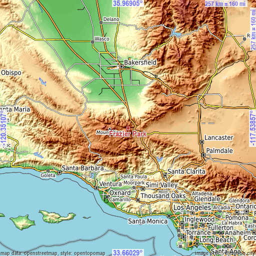
| \ | Map #1 | Topo.Map |
| Scale [m] | 1217..2385 m | × |
| Scale [ft] | 3993..7825 ft | × |
| Average | 1735.5 m = 5694 ft | × |
| Width | 8.02 km = 5 mi | 256.7 km = 159.5 mi |
| Height | 8.02 km = 5 mi | 256.7 km = 159.5 mi |
| ↑Max Latitude | 34.858828° | 35.96905° |
| Latitude at center | 34.82276° | 34.82276° |
| ↓Min Latitude | 34.786676° | 33.66029° |
| ← Min Longitude | -118.988765° | -120.35107° |
| Longitude center | -118.94482° | -118.94482° |
| →Max Longitude | -118.900875° | -117.53857° |
Nearby cities:
Cities around Frazier Park sort by population:
• Arvin elevation 137 m
44.2 km,  13°
13°
• Castaic 374 m
47.4 km,  141°
141°
• Fillmore 143 m
47.2 km,  177°
177°
• Lamont 123 m
48.7 km,  3°
3°
• Bear Valley Springs 1255 m
47.2 km,  37°
37°
• Weedpatch 117 m
46.3 km, 3°
• Stallion Springs 1157 m
40.4 km, 42°
• Val Verde 364 m
49.5 km,  147°
147°
• Pine Mountain Club 1714 m
18.9 km,  277°
277°
• Piru 218 m
47.4 km,  163°
163°
• Lebec 1065 m
7.6 km,  73°
73°
• Maricopa 267 m
49.2 km,  302°
302°
Multilingual:
 En español:
Frazier Park elevación 1416 m.
 En France:
Frazier Park élévation 1416 m.
 Auf Deutsch:
Frazier Park höhe über dem Meeresspiegel ist 1416 m.

Sources and notes:
- [note 1] Map square and city borders are not equal. Map elevation data is calculated only from area inside that square.
- [src 1] Elevation data from geonames database provided with same terms of usage.
- [src 2] The elevation map of Frazier Park is generated using elevation data from NASA's 3 arcsec (90m) resolution SRTM data.
- [src 3] Base (background) map © OpenStreetMap contributors tiles are generated by Geofabrik and OpenTopoMap.
Copyright & License:
This Frazier Park Elevation Map is licensed under CC BY-SA. You may reuse any part from this page, if you give a proper credit by linking to this URL:
 More info on terms of use page.