Delano elevation
Delano (California, Kern County), United States elevation is 100 meters and Delano elevation in feet is 328 ft above sea level [src 1]. Delano is a populated place (feature code) with elevation that is 179 meters (587 ft) smaller than average city elevation in United States.
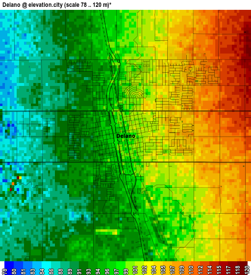
Below is the Elevation map of Delano, which displays elevation range with different colors. Scale of the first map is from 78 to 120 m (256 to 394 ft) with average elevation of 97.7 meters (=321 ft) [note 1]
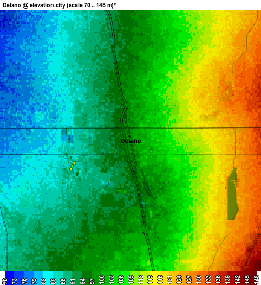
These maps also provides idea of topography and contour of this city, they are displayed at different zoom levels. More info about maps, scale and edge coordinates you can find below images.
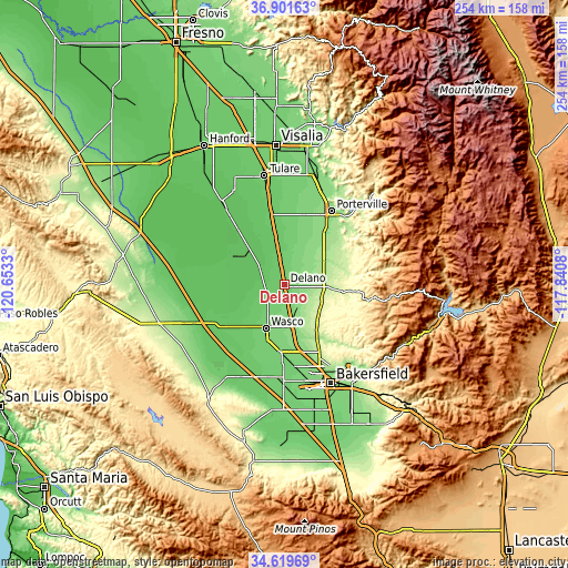
| \ | Map #1 | Map #2 | Topo.Map |
| Scale [m] | 78..120 m | 70..148 m | × |
| Scale [ft] | 256..394 ft | 230..486 ft | × |
| Average | 97.7 m = 321 ft | 100.5 m = 330 ft | × |
| Width | 7.93 km = 4.9 mi | 15.86 km = 9.9 mi | 253.7 km = 157.6 mi |
| Height | 7.93 km = 4.9 mi | 15.86 km = 9.9 mi | 253.7 km = 157.6 mi |
| ↑Max Latitude | 35.804488° | 35.840121° | 36.90163° |
| Latitude at center | 35.76884° | 35.76884° | 35.76884° |
| ↓Min Latitude | 35.733176° | 35.697495° | 34.61969° |
| ← Min Longitude | -119.290995° | -119.334941° | -120.6533° |
| Longitude center | -119.24705° | -119.24705° | -119.24705° |
| →Max Longitude | -119.203105° | -119.159159° | -117.8408° |
Nearby cities:
Cities around Delano sort by population:
• Wasco elevation 101 m
21.2 km,  203°
203°
• Shafter 107 m
29.9 km,  184°
184°
• McFarland 110 m
10.2 km,  170°
170°
• Earlimart 88 m
13 km,  349°
349°
• Terra Bella 150 m
28.2 km,  40°
40°
• Pixley 83 m
22.6 km, 349°
• Richgrove 160 m
12.9 km,  76°
76°
• Tipton 84 m
32.8 km, 349°
• Poplar-Cotton Center 113 m
33.2 km,  15°
15°
• Woodville 105 m
36.4 km,  6°
6°
• Teviston 83 m
18 km, 351°
• Alpaugh 64 m
25.4 km,  301°
301°
Multilingual:
 En español:
Delano elevación 100 m.
 En France:
Delano élévation 100 m.


Sources and notes:
- [note 1] Map square and city borders are not equal. Map elevation data is calculated only from area inside that square.
- [src 1] Elevation data from geonames database provided with same terms of usage.
- [src 2] The elevation map of Delano is generated using elevation data from NASA's 3 arcsec (90m) resolution SRTM data.
- [src 3] Base (background) map © OpenStreetMap contributors tiles are generated by Geofabrik and OpenTopoMap.
Copyright & License:
This Delano Elevation Map is licensed under CC BY-SA. You may reuse any part from this page, if you give a proper credit by linking to this URL:
 More info on terms of use page.