Copperopolis elevation
Copperopolis (California, Calaveras County), United States elevation is 306 meters and Copperopolis elevation in feet is 1004 ft above sea level [src 1]. Copperopolis is a populated place (feature code) with elevation that is 27 meters (89 ft) bigger than average city elevation in United States.
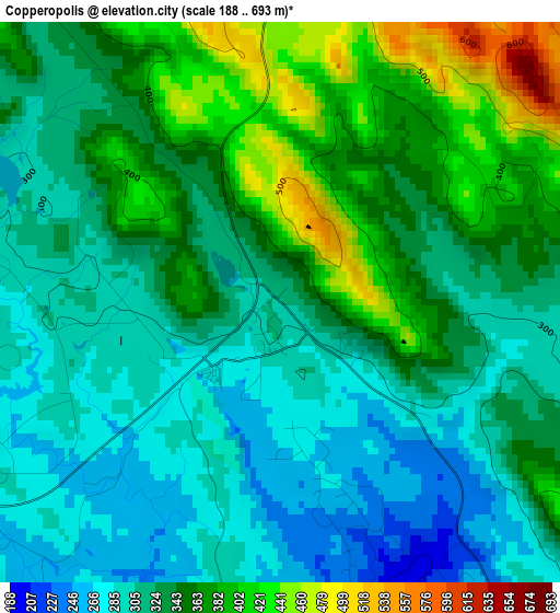
Below is the Elevation map of Copperopolis, which displays elevation range with different colors. Scale of the first map is from 188 to 693 m (617 to 2274 ft) with average elevation of 336.7 meters (=1105 ft) [note 1]
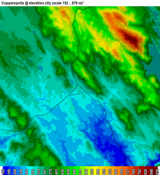
These maps also provides idea of topography and contour of this city, they are displayed at different zoom levels. More info about maps, scale and edge coordinates you can find below images.
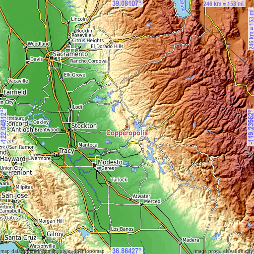
| \ | Map #1 | Map #2 | Topo.Map |
| Scale [m] | 188..693 m | 152..876 m | × |
| Scale [ft] | 617..2274 ft | 499..2874 ft | × |
| Average | 336.7 m = 1105 ft | 367.2 m = 1205 ft | × |
| Width | 7.7 km = 4.8 mi | 15.41 km = 9.6 mi | 246.5 km = 153.2 mi |
| Height | 7.7 km = 4.8 mi | 15.41 km = 9.6 mi | 246.5 km = 153.2 mi |
| ↑Max Latitude | 38.01567° | 38.050284° | 39.08107° |
| Latitude at center | 37.98104° | 37.98104° | 37.98104° |
| ↓Min Latitude | 37.946393° | 37.911731° | 36.86427° |
| ← Min Longitude | -120.685815° | -120.729761° | -122.04812° |
| Longitude center | -120.64187° | -120.64187° | -120.64187° |
| →Max Longitude | -120.597925° | -120.553979° | -119.23562° |
Nearby cities:
Cities around Copperopolis sort by population:
• Sonora elevation 551 m
22.8 km,  89°
89°
• Rancho Calaveras 168 m
25 km,  310°
310°
• Valley Springs 208 m
28.6 km,  325°
325°
• Jamestown 430 m
19.5 km,  99°
99°
• San Andreas 310 m
24.1 km,  351°
351°
• East Oakdale 44 m
25.7 km,  213°
213°
• Angels Camp 431 m
13.2 km,  42°
42°
• Columbia 658 m
22 km,  73°
73°
• East Sonora 640 m
24.6 km, 90°
• Murphys 662 m
23.5 km, 42°
• Mountain Ranch 650 m
28.9 km,  17°
17°
• Forest Meadows 1031 m
29.3 km, 44°
Multilingual:
 En español:
Copperopolis elevación 306 m.
 En France:
Copperopolis élévation 306 m.
 Auf Deutsch:
Copperopolis höhe über dem Meeresspiegel ist 306 m.

Sources and notes:
- [note 1] Map square and city borders are not equal. Map elevation data is calculated only from area inside that square.
- [src 1] Elevation data from geonames database provided with same terms of usage.
- [src 2] The elevation map of Copperopolis is generated using elevation data from NASA's 3 arcsec (90m) resolution SRTM data.
- [src 3] Base (background) map © OpenStreetMap contributors tiles are generated by Geofabrik and OpenTopoMap.
Copyright & License:
This Copperopolis Elevation Map is licensed under CC BY-SA. You may reuse any part from this page, if you give a proper credit by linking to this URL:
 More info on terms of use page.