East Sonora elevation
East Sonora (California, Tuolumne County), United States elevation is 640 meters and East Sonora elevation in feet is 2100 ft above sea level [src 1]. East Sonora is a populated place (feature code) with elevation that is 361 meters (1184 ft) bigger than average city elevation in United States.
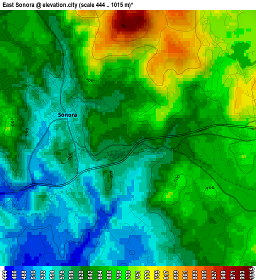
Below is the Elevation map of East Sonora, which displays elevation range with different colors. Scale of the first map is from 444 to 1015 m (1457 to 3330 ft) with average elevation of 646.4 meters (=2121 ft) [note 1]
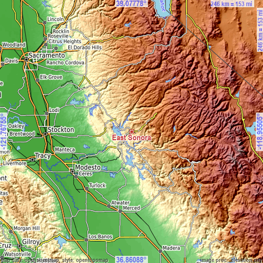
These maps also provides idea of topography and contour of this city, they are displayed at different zoom levels. More info about maps, scale and edge coordinates you can find below images.
| \ | Map #1 | Topo.Map |
| Scale [m] | 444..1015 m | × |
| Scale [ft] | 1457..3330 ft | × |
| Average | 646.4 m = 2121 ft | × |
| Width | 7.7 km = 4.8 mi | 246.5 km = 153.2 mi |
| Height | 7.7 km = 4.8 mi | 246.5 km = 153.2 mi |
| ↑Max Latitude | 38.012332° | 39.07778° |
| Latitude at center | 37.9777° | 37.9777° |
| ↓Min Latitude | 37.943052° | 36.86088° |
| ← Min Longitude | -120.405245° | -121.76755° |
| Longitude center | -120.3613° | -120.3613° |
| →Max Longitude | -120.317355° | -118.95505° |
Nearby cities:
Cities around East Sonora sort by population:
• Sonora elevation 551 m
2 km,  291°
291°
• Phoenix Lake 748 m
5.7 km,  56°
56°
• Jamestown 430 m
6 km,  243°
243°
• Mono Vista 909 m
8.3 km,  74°
74°
• Angels Camp 431 m
18.6 km,  302°
302°
• Columbia 658 m
7.4 km,  331°
331°
• Twain Harte 1125 m
13.2 km, 58°
• Soulsbyville 895 m
8.6 km,  84°
84°
• Murphys 662 m
19.8 km, 333°
• Tuolumne City 786 m
10.6 km,  99°
99°
• Forest Meadows 1031 m
21.6 km,  349°
349°
• Cedar Ridge 1150 m
12.3 km,  37°
37°
Multilingual:
 En español:
East Sonora elevación 640 m.
 En France:
East Sonora élévation 640 m.
 Auf Deutsch:
East Sonora höhe über dem Meeresspiegel ist 640 m.

Sources and notes:
- [note 1] Map square and city borders are not equal. Map elevation data is calculated only from area inside that square.
- [src 1] Elevation data from geonames database provided with same terms of usage.
- [src 2] The elevation map of East Sonora is generated using elevation data from NASA's 3 arcsec (90m) resolution SRTM data.
- [src 3] Base (background) map © OpenStreetMap contributors tiles are generated by Geofabrik and OpenTopoMap.
Copyright & License:
This East Sonora Elevation Map is licensed under CC BY-SA. You may reuse any part from this page, if you give a proper credit by linking to this URL:
 More info on terms of use page.