Coalinga elevation
Coalinga (California, Fresno County), United States elevation is 207 meters and Coalinga elevation in feet is 679 ft above sea level [src 1]. Coalinga is a populated place (feature code) with elevation that is 72 meters (236 ft) smaller than average city elevation in United States.
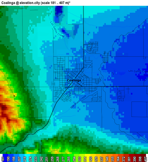
Below is the Elevation map of Coalinga, which displays elevation range with different colors. Scale of the first map is from 181 to 407 m (594 to 1335 ft) with average elevation of 225 meters (=738 ft) [note 1]
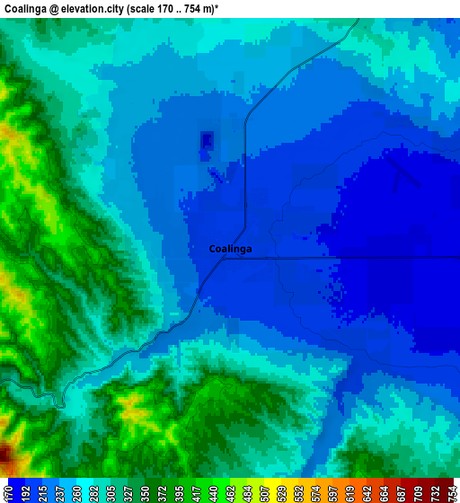
These maps also provides idea of topography and contour of this city, they are displayed at different zoom levels. More info about maps, scale and edge coordinates you can find below images.
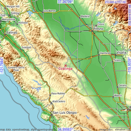
| \ | Map #1 | Map #2 | Topo.Map |
| Scale [m] | 181..407 m | 170..754 m | × |
| Scale [ft] | 594..1335 ft | 558..2474 ft | × |
| Average | 225 m = 738 ft | 275.2 m = 903 ft | × |
| Width | 7.89 km = 4.9 mi | 15.78 km = 9.8 mi | 252.5 km = 156.9 mi |
| Height | 7.89 km = 4.9 mi | 15.78 km = 9.8 mi | 252.5 km = 156.9 mi |
| ↑Max Latitude | 36.175161° | 36.210627° | 37.26709° |
| Latitude at center | 36.13968° | 36.13968° | 36.13968° |
| ↓Min Latitude | 36.104183° | 36.068669° | 34.99583° |
| ← Min Longitude | -120.404095° | -120.448041° | -121.7664° |
| Longitude center | -120.36015° | -120.36015° | -120.36015° |
| →Max Longitude | -120.316205° | -120.272259° | -118.9539° |
Nearby cities:
Cities around Coalinga sort by population:
• Paso Robles elevation 231 m
64.4 km,  207°
207°
• Lemoore 70 m
54.8 km,  70°
70°
• Avenal 248 m
25.7 km,  125°
125°
• Lemoore Station 71 m
43.1 km, 71°
• Huron 111 m
24.1 km, 73°
• Armona 74 m
61.6 km, 71°
• San Joaquin 56 m
54.1 km,  16°
16°
• Riverdale 68 m
55.3 km,  54°
54°
• San Miguel 192 m
52.6 km,  215°
215°
• Kettleman City 81 m
38.7 km,  112°
112°
• Shandon 318 m
53.9 km,  181°
181°
• Stratford 61 m
48.5 km,  83°
83°
Multilingual:
 En español:
Coalinga elevación 207 m.
 En France:
Coalinga élévation 207 m.
 Auf Deutsch:
Coalinga höhe über dem Meeresspiegel ist 207 m.

Sources and notes:
- [note 1] Map square and city borders are not equal. Map elevation data is calculated only from area inside that square.
- [src 1] Elevation data from geonames database provided with same terms of usage.
- [src 2] The elevation map of Coalinga is generated using elevation data from NASA's 3 arcsec (90m) resolution SRTM data.
- [src 3] Base (background) map © OpenStreetMap contributors tiles are generated by Geofabrik and OpenTopoMap.
Copyright & License:
This Coalinga Elevation Map is licensed under CC BY-SA. You may reuse any part from this page, if you give a proper credit by linking to this URL:
 More info on terms of use page.