Stratford elevation
Stratford (California, Kings County), United States elevation is 61 meters and Stratford elevation in feet is 200 ft above sea level [src 1]. Stratford is a populated place (feature code) with elevation that is 218 meters (715 ft) smaller than average city elevation in United States.
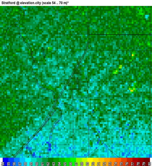
Below is the Elevation map of Stratford, which displays elevation range with different colors. Scale of the first map is from 54 to 70 m (177 to 230 ft) with average elevation of 60.8 meters (=199 ft) [note 1]
These maps also provides idea of topography and contour of this city, they are displayed at different zoom levels. More info about maps, scale and edge coordinates you can find below images.
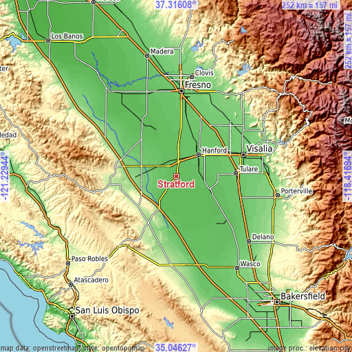
| \ | Map #1 | Topo.Map |
| Scale [m] | 54..70 m | × |
| Scale [ft] | 177..230 ft | × |
| Average | 60.8 m = 199 ft | × |
| Width | 7.89 km = 4.9 mi | 252.4 km = 156.8 mi |
| Height | 7.89 km = 4.9 mi | 252.4 km = 156.8 mi |
| ↑Max Latitude | 36.224859° | 37.31608° |
| Latitude at center | 36.1894° | 36.1894° |
| ↓Min Latitude | 36.153925° | 35.04627° |
| ← Min Longitude | -119.867135° | -121.22944° |
| Longitude center | -119.82319° | -119.82319° |
| →Max Longitude | -119.779245° | -118.41694° |
Nearby cities:
Cities around Stratford sort by population:
• Hanford elevation 80 m
22.1 km,  46°
46°
• Lemoore 70 m
12.9 km,  16°
16°
• Corcoran 64 m
25.7 km,  113°
113°
• Avenal 248 m
34.3 km,  233°
233°
• Lemoore Station 71 m
11 km,  318°
318°
• Huron 111 m
25.1 km,  273°
273°
• Armona 74 m
17.4 km,  36°
36°
• Lucerne 79 m
25.6 km,  33°
33°
• Riverdale 68 m
27.1 km,  353°
353°
• Laton 80 m
29.7 km, 24°
• Home Garden 72 m
21 km, 52°
• Kettleman City 81 m
23.7 km,  211°
211°
Multilingual:
 En español:
Stratford elevación 61 m.
 En France:
Stratford élévation 61 m.
 Auf Deutsch:
Stratford höhe über dem Meeresspiegel ist 61 m.

Sources and notes:
- [note 1] Map square and city borders are not equal. Map elevation data is calculated only from area inside that square.
- [src 1] Elevation data from geonames database provided with same terms of usage.
- [src 2] The elevation map of Stratford is generated using elevation data from NASA's 3 arcsec (90m) resolution SRTM data.
- [src 3] Base (background) map © OpenStreetMap contributors tiles are generated by Geofabrik and OpenTopoMap.
Copyright & License:
This Stratford Elevation Map is licensed under CC BY-SA. You may reuse any part from this page, if you give a proper credit by linking to this URL:
 More info on terms of use page.